
Scientists at ORNL used neutron scattering and supercomputing to better understand how an organic solvent and water work together to break down plant biomass, creating a pathway to significantly improve the production of renewable
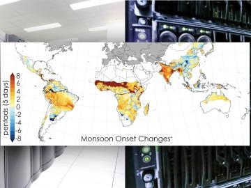
Scientists from the Department of Energy’s Oak Ridge National Laboratory and a dozen other international research institutions have produced the most elaborate set of projections to date that illustrates possible futures for major monsoon regions.

For the second year in a row, a team from the Department of Energy’s Oak Ridge and Los Alamos national laboratories led a demonstration hosted by EPB, a community-based utility and telecommunications company serving Chattanooga, Tennessee.
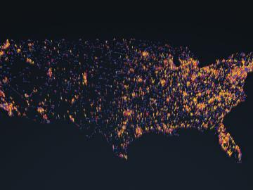
OAK RIDGE, Tenn., May 5, 2020 — By 2050, the United States will likely be exposed to a larger number of extreme climate events, including more frequent heat waves, longer droughts and more intense floods, which can lead to greater risks for human health, ecosystem stability and regional economies.

A novel approach developed by scientists at ORNL can scan massive datasets of large-scale satellite images to more accurately map infrastructure – such as buildings and roads – in hours versus days.
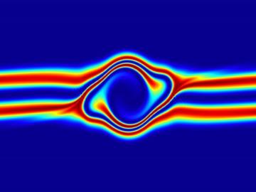
The prospect of simulating a fusion plasma is a step closer to reality thanks to a new computational tool developed by scientists in fusion physics, computer science and mathematics at ORNL.

An international team of scientists, led by the University of Manchester, has developed a metal-organic framework, or MOF, material

Researchers used neutron scattering at Oak Ridge National Laboratory’s Spallation Neutron Source to investigate the effectiveness of a novel crystallization method to capture carbon dioxide directly from the air.
OAK RIDGE, Tenn., Feb. 12, 2019—A team of researchers from the Department of Energy’s Oak Ridge and Los Alamos National Laboratories has partnered with EPB, a Chattanooga utility and telecommunications company, to demonstrate the effectiveness of metro-scale quantum key distribution (QKD).

A team of scientists led by Oak Ridge National Laboratory used machine learning methods to generate a high-resolution map of vegetation growing in the remote reaches of the Alaskan tundra.