Filter News
Area of Research
News Topics
- (-) Environment (29)
- (-) High-Performance Computing (3)
- (-) Microscopy (8)
- (-) Neutron Science (30)
- 3-D Printing/Advanced Manufacturing (28)
- Advanced Reactors (14)
- Artificial Intelligence (8)
- Big Data (11)
- Bioenergy (12)
- Biology (5)
- Biomedical (21)
- Biotechnology (2)
- Buildings (1)
- Chemical Sciences (5)
- Clean Water (2)
- Climate Change (10)
- Composites (1)
- Computer Science (39)
- Coronavirus (23)
- Critical Materials (2)
- Cybersecurity (4)
- Decarbonization (1)
- Energy Storage (21)
- Exascale Computing (3)
- Frontier (1)
- Fusion (13)
- Grid (7)
- Isotopes (8)
- Machine Learning (8)
- Materials (2)
- Materials Science (37)
- Mathematics (2)
- Mercury (1)
- Molten Salt (2)
- Nanotechnology (17)
- National Security (2)
- Nuclear Energy (31)
- Physics (13)
- Polymers (7)
- Quantum Science (14)
- Security (3)
- Space Exploration (2)
- Summit (17)
- Sustainable Energy (24)
- Transformational Challenge Reactor (5)
- Transportation (15)
Media Contacts
![Examples from the ORNL Overhead Vehicle Dataset, generated with images captured by GRIDSMART cameras. Image: Thomas Karnowski/ORNL](/sites/default/files/styles/list_page_thumbnail/public/2020-02/truckgrid-corrected-1024x745.png?h=bc62b519&itok=HY9xstgl)
Each year, approximately 6 billion gallons of fuel are wasted as vehicles wait at stop lights or sit in dense traffic with engines idling, according to US Department of Energy estimates.
A team of scientists led by Oak Ridge National Laboratory found that while all regions of the country can expect an earlier start to the growing season as temperatures rise, the trend is likely to become more variable year-over-year in hotter regions.
![A new computational approach by ORNL can more quickly scan large-scale satellite images, such as these of Puerto Rico, for more accurate mapping of complex infrastructure like buildings. Credit: Maxar Technologies and Dalton Lunga/Oak Ridge National Laboratory, U.S. Dept. of Energy](/sites/default/files/styles/list_page_thumbnail/public/2020-02/Puerto_Rico_Resflow9.png?h=a0a1befd&itok=5n2fss_e)
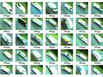
A novel approach developed by scientists at ORNL can scan massive datasets of large-scale satellite images to more accurately map infrastructure – such as buildings and roads – in hours versus days.
![Scanning probe microscopes use an atom-sharp tip—only a few nanometers thick—to image materials on a nanometer length scale. The probe tip, invisible to the eye, is attached to a cantilever (pictured) that moves across material surfaces like the tone arm on a record player. Credit: Genevieve Martin/Oak Ridge National Laboratory; U.S. Dept. of Energy.](/sites/default/files/styles/list_page_thumbnail/public/2020-01/2019-P15115.jpg?h=c6980913&itok=o69jyoNw)
Liam Collins was drawn to study physics to understand “hidden things” and honed his expertise in microscopy so that he could bring them to light.