Filter News
Area of Research
Media Contacts
![The image shows a visualization of a radiation transport simulation for a spaceflight radioisotope power system and complex interactions of radiation fields with operational environments. Credit: Michael B. R. Smith and M. Scott Greenwood/ORNL, U.S. Dept. of Energy](/sites/default/files/styles/list_page_thumbnail/public/2020-11/Radiation%20-%20video%20game%20visualization_0.jpg?h=caea307d&itok=e3nK2b2_)
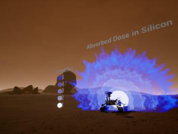
Researchers at Oak Ridge National Laboratory are developing a first-of-a-kind toolkit drawing on video game development software to visualize radiation data.
![Colorized micrograph of lily pollen](/sites/default/files/styles/list_page_thumbnail/public/2020-07/Lily_CH%20and%20CO_1.png?h=436b82d4&itok=lntoWKVr)
Oak Ridge National Laboratory researchers have built a novel microscope that provides a “chemical lens” for viewing biological systems including cell membranes and biofilms.
![GIS – LandScan goes public](/sites/default/files/styles/list_page_thumbnail/public/2020-05/sanfran%20%281%29_2.png?h=ea18fbc4&itok=c_VbFqAC)
Oak Ridge National Laboratory’s high-resolution population distribution database, LandScan USA, became permanently available to researchers in time to aid the response to the novel coronavirus pandemic.
![Materials — Molding molecular matter](/sites/default/files/styles/list_page_thumbnail/public/2020-04/Ebeam_IMAGE_Final_0.jpg?h=c4322a57&itok=uYF8ugqx)
Scientists at Oak Ridge National Laboratory used a focused beam of electrons to stitch platinum-silicon molecules into graphene, marking the first deliberate insertion of artificial molecules into a graphene host matrix.
![A new computational approach by ORNL can more quickly scan large-scale satellite images, such as these of Puerto Rico, for more accurate mapping of complex infrastructure like buildings. Credit: Maxar Technologies and Dalton Lunga/Oak Ridge National Laboratory, U.S. Dept. of Energy](/sites/default/files/styles/list_page_thumbnail/public/2020-02/Puerto_Rico_Resflow9.png?h=a0a1befd&itok=5n2fss_e)
A novel approach developed by scientists at ORNL can scan massive datasets of large-scale satellite images to more accurately map infrastructure – such as buildings and roads – in hours versus days.
![Smart Neighborhood homes](/sites/default/files/styles/list_page_thumbnail/public/2020-01/04.09.TD-SMartHome_0.jpg?h=5b5a5437&itok=22S5Tle1)
To better determine the potential energy cost savings among connected homes, researchers at Oak Ridge National Laboratory developed a computer simulation to more accurately compare energy use on similar weather days.