Six ORNL scientists have been elected as fellows to the American Association for the Advancement of Science, or AAAS. Credit: ORNL, U.S. Dept. of Energy

Six ORNL scientists have been elected as fellows to the American Association for the Advancement of Science, or AAAS.

Fuel pellets sometimes degrade to a sandlike consistency and can disperse into the reactor core if a rod’s cladding bursts. ORNL researchers are studying how often this happens and what impact it has, in order to let reactors operate as long as possible without increasing risk.

A developing method to gauge the occurrence of a nuclear reactor anomaly has the potential to save millions of dollars.

Hector J. Santos-Villalobos, left, and Oscar A. Martinez

Two staff members at the Department of Energy’s Oak Ridge National Laboratory have received prestigious HENAAC and Luminary Awards from Great Minds in STEM, a nonprofit organization that focuses on promoting STEM careers in underserved 

Andrew Harter, pictured, and fellow ORNL staff members formed Horizon31 to build a set of products and services that provide customized unmanned vehicle control systems. Credit: Carlos Jones/ORNL, U.S. Dept. of Energy

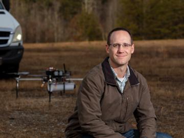
Horizon31, LLC has exclusively licensed a novel communication system that allows users to reliably operate unmanned vehicles such as drones from anywhere in the world using only an internet connection.

 Using the ASGarD mathematical framework, scientists can model and visualize the electric fields, shown as arrows, circling around magnetic fields that are colorized to represent field magnitude of a fusion plasma. Credit: David Green/ORNL

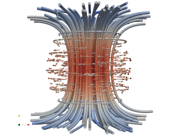
Combining expertise in physics, applied math and computing, Oak Ridge National Laboratory scientists are expanding the possibilities for simulating electromagnetic fields that underpin phenomena in materials design and telecommunications.

A new computational approach by ORNL can more quickly scan large-scale satellite images, such as these of Puerto Rico, for more accurate mapping of complex infrastructure like buildings. Credit: Maxar Technologies and Dalton Lunga/Oak Ridge National Laboratory, U.S. Dept. of Energy

A novel approach developed by scientists at ORNL can scan massive datasets of large-scale satellite images to more accurately map infrastructure – such as buildings and roads – in hours versus days.