Filter News
Area of Research
- (-) Materials (7)
- (-) Supercomputing (8)
- Biology and Environment (8)
- Clean Energy (27)
- Climate and Environmental Systems (2)
- Fusion and Fission (3)
- Fusion Energy (4)
- Materials for Computing (1)
- National Security (4)
- Neutron Science (5)
- Nuclear Science and Technology (9)
- Quantum information Science (1)
News Topics
- (-) Bioenergy (5)
- (-) Environment (7)
- (-) Frontier (1)
- (-) Fusion (1)
- (-) Molten Salt (1)
- (-) Security (1)
- 3-D Printing/Advanced Manufacturing (6)
- Advanced Reactors (1)
- Artificial Intelligence (5)
- Big Data (8)
- Biology (1)
- Biomedical (8)
- Chemical Sciences (2)
- Climate Change (1)
- Computer Science (29)
- Coronavirus (8)
- Critical Materials (2)
- Cybersecurity (1)
- Decarbonization (1)
- Energy Storage (8)
- Exascale Computing (2)
- Grid (2)
- High-Performance Computing (2)
- Isotopes (1)
- Machine Learning (4)
- Materials (2)
- Materials Science (32)
- Mathematics (1)
- Microscopy (5)
- Nanotechnology (13)
- National Security (1)
- Neutron Science (16)
- Nuclear Energy (4)
- Physics (8)
- Polymers (4)
- Quantum Science (10)
- Summit (13)
- Sustainable Energy (7)
- Transformational Challenge Reactor (2)
- Transportation (4)
Media Contacts
![Simulations forecast nationwide increase in human exposure to extreme climate events](/sites/default/files/styles/list_page_thumbnail/public/2020-05/us_population_exposure_0.jpg?h=854a7be2&itok=sagvawwJ)
OAK RIDGE, Tenn., May 5, 2020 — By 2050, the United States will likely be exposed to a larger number of extreme climate events, including more frequent heat waves, longer droughts and more intense floods, which can lead to greater risks for human health, ecosystem stability and regional economies.
![A new computational approach by ORNL can more quickly scan large-scale satellite images, such as these of Puerto Rico, for more accurate mapping of complex infrastructure like buildings. Credit: Maxar Technologies and Dalton Lunga/Oak Ridge National Laboratory, U.S. Dept. of Energy](/sites/default/files/styles/list_page_thumbnail/public/2020-02/Puerto_Rico_Resflow9.png?h=a0a1befd&itok=5n2fss_e)
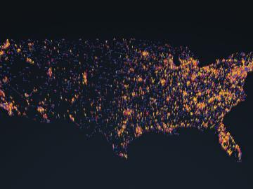
A novel approach developed by scientists at ORNL can scan massive datasets of large-scale satellite images to more accurately map infrastructure – such as buildings and roads – in hours versus days.
![This simulation of a fusion plasma calculation result shows the interaction of two counter-streaming beams of super-heated gas. Credit: David L. Green/Oak Ridge National Laboratory, U.S. Dept. of Energy](/sites/default/files/styles/list_page_thumbnail/public/2020-02/Fusion_plasma_simulation.jpg?h=d0852d1e&itok=CDWgjLPL)
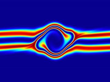
The prospect of simulating a fusion plasma is a step closer to reality thanks to a new computational tool developed by scientists in fusion physics, computer science and mathematics at ORNL.