Filter News
Area of Research
- (-) Mathematics (1)
- (-) National Security (22)
- Advanced Manufacturing (6)
- Biology and Environment (107)
- Biology and Soft Matter (1)
- Clean Energy (172)
- Climate and Environmental Systems (5)
- Computational Biology (1)
- Computational Engineering (2)
- Computer Science (8)
- Electricity and Smart Grid (3)
- Functional Materials for Energy (1)
- Fusion and Fission (10)
- Fusion Energy (3)
- Isotope Development and Production (1)
- Isotopes (5)
- Materials (104)
- Materials Characterization (1)
- Materials for Computing (19)
- Materials Under Extremes (1)
- Neutron Science (46)
- Nuclear Science and Technology (9)
- Quantum information Science (1)
- Sensors and Controls (1)
- Supercomputing (92)
- Transportation Systems (2)
News Topics
- (-) Big Data (6)
- (-) Coronavirus (2)
- (-) Environment (6)
- (-) Frontier (1)
- (-) Grid (6)
- (-) Materials Science (3)
- (-) Transportation (2)
- 3-D Printing/Advanced Manufacturing (2)
- Advanced Reactors (1)
- Artificial Intelligence (12)
- Bioenergy (3)
- Biology (5)
- Biomedical (2)
- Biotechnology (1)
- Buildings (1)
- Chemical Sciences (2)
- Clean Water (1)
- Climate Change (6)
- Computer Science (20)
- Cybersecurity (19)
- Decarbonization (2)
- Energy Storage (2)
- Exascale Computing (1)
- Fusion (1)
- High-Performance Computing (4)
- Machine Learning (12)
- Materials (2)
- Mathematics (1)
- Nanotechnology (1)
- National Security (34)
- Neutron Science (4)
- Nuclear Energy (5)
- Partnerships (4)
- Physics (1)
- Quantum Science (1)
- Security (11)
- Simulation (1)
- Summit (2)
- Sustainable Energy (3)
Media Contacts
![LandScan Global depicts population distribution estimates across the planet. The darker orange and red colors above indicate higher population density. Credit: ORNL, U.S. Dept. of Energy](/sites/default/files/styles/list_page_thumbnail/public/2022-05/Picture1_0.jpg?h=9d172ced&itok=uYwYp-pW)
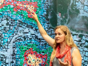
It’s a simple premise: To truly improve the health, safety, and security of human beings, you must first understand where those individuals are.
![ORNL, VA and Harvard researchers developed a sparse matrix full of anonymized information on what is thought to be the largest cohort of healthcare data used for this type of research in the U.S. The matrix can be probed with different methods, such as KESER, to gain new insights into human health. Credit: Nathan Armistead/ORNL, U.S. Dept. of Energy](/sites/default/files/styles/list_page_thumbnail/public/2022-04/2022-G00330_KESER%20Illustration_0.jpg?h=1cb48fc4&itok=c6ZuDdDg)
A team of researchers has developed a novel, machine learning–based technique to explore and identify relationships among medical concepts using electronic health record data across multiple healthcare providers.
![ORNL research scientist Christa Brelsford explained a mathematical framework she developed in 2018, which showed increased availability of infrastructure didn’t necessarily reduce inequality in its access. Credit: Carlos Jones/ORNL, U.S. Dept. of Energy](/sites/default/files/styles/list_page_thumbnail/public/2022-04/image001.jpg?h=1579b22a&itok=XzIna_Uc)
Unequal access to modern infrastructure is a feature of growing cities, according to a study published this week in the Proceedings of the National Academy of Sciences
![ORNL Image](/sites/default/files/styles/list_page_thumbnail/public/SE_elec_consumption_withPplants.jpg?h=50ec1d8e&itok=SqxQDFw8)
An analysis published in the Proceedings of the National Academy of Sciences and led by researchers from the U.S. Department of Energy’s Oak Ridge National Laboratory has received the 2021 Sustainability Science Award from the Ecological Society of America.
![Urban climate modeling](/sites/default/files/styles/list_page_thumbnail/public/2021-03/urbanclimate_sized.jpeg?h=0d9d21a1&itok=-ICe9HqY)
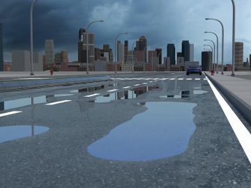
Researchers at Oak Ridge National Laboratory have identified a statistical relationship between the growth of cities and the spread of paved surfaces like roads and sidewalks. These impervious surfaces impede the flow of water into the ground, affecting the water cycle and, by extension, the climate.
![Six ORNL scientists have been elected as fellows to the American Association for the Advancement of Science, or AAAS. Credit: ORNL, U.S. Dept. of Energy](/sites/default/files/styles/list_page_thumbnail/public/2020-11/AAASfellows.jpg?h=d761c044&itok=opKRkA17)
Six ORNL scientists have been elected as fellows to the American Association for the Advancement of Science, or AAAS.
![The CrossVis application includes a parallel coordinates plot (left), a tiled image view (right) and other interactive data views. Credit: Chad Steed/Oak Ridge National Laboratory, U.S. Dept. of Energy](/sites/default/files/styles/list_page_thumbnail/public/2020-07/CrossVisOverview_2.png?h=fd2b4cf7&itok=Mz8wRoMo)
From materials science and earth system modeling to quantum information science and cybersecurity, experts in many fields run simulations and conduct experiments to collect the abundance of data necessary for scientific progress.
![Recent research involving Oak Ridge National Laboratory’s Spallation Neutron Source demonstrates crystal-like heat conduction in a solid-liquid hybrid, AgCrSe2.](/sites/default/files/styles/list_page_thumbnail/public/2020-05/NIEDZELA_PNAS_graphic_0.png?h=39b94f55&itok=CA3sJhdS)
Research by an international team led by Duke University and the Department of Energy’s Oak Ridge National Laboratory scientists could speed the way to safer rechargeable batteries for consumer electronics such as laptops and cellphones.
![GIS – LandScan goes public](/sites/default/files/styles/list_page_thumbnail/public/2020-05/sanfran%20%281%29_2.png?h=ea18fbc4&itok=c_VbFqAC)
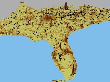
Oak Ridge National Laboratory’s high-resolution population distribution database, LandScan USA, became permanently available to researchers in time to aid the response to the novel coronavirus pandemic.
![A new computational approach by ORNL can more quickly scan large-scale satellite images, such as these of Puerto Rico, for more accurate mapping of complex infrastructure like buildings. Credit: Maxar Technologies and Dalton Lunga/Oak Ridge National Laboratory, U.S. Dept. of Energy](/sites/default/files/styles/list_page_thumbnail/public/2020-02/Puerto_Rico_Resflow9.png?h=a0a1befd&itok=5n2fss_e)
A novel approach developed by scientists at ORNL can scan massive datasets of large-scale satellite images to more accurately map infrastructure – such as buildings and roads – in hours versus days.