![White car (Porsche Taycan) with the hood popped is inside the building with an american flag on the wall.](/sites/default/files/styles/featured_square_large/public/2024-06/2024-P09317.jpg?h=8f9cfe54&itok=m6sQhZRq)
Filter News
Area of Research
- (-) National Security (21)
- Advanced Manufacturing (7)
- Biology and Environment (28)
- Clean Energy (106)
- Computational Engineering (2)
- Computer Science (7)
- Electricity and Smart Grid (1)
- Functional Materials for Energy (1)
- Fusion and Fission (12)
- Fusion Energy (9)
- Isotope Development and Production (1)
- Isotopes (4)
- Materials (92)
- Materials Characterization (1)
- Materials for Computing (18)
- Materials Under Extremes (1)
- Mathematics (1)
- Neutron Science (35)
- Nuclear Science and Technology (17)
- Nuclear Systems Modeling, Simulation and Validation (1)
- Supercomputing (76)
- Transportation Systems (2)
News Topics
- (-) Advanced Reactors (1)
- (-) Big Data (6)
- (-) Exascale Computing (1)
- (-) Frontier (1)
- (-) Machine Learning (12)
- (-) Materials Science (3)
- (-) Transportation (2)
- 3-D Printing/Advanced Manufacturing (2)
- Artificial Intelligence (12)
- Bioenergy (3)
- Biology (5)
- Biomedical (2)
- Biotechnology (1)
- Buildings (1)
- Chemical Sciences (2)
- Climate Change (5)
- Computer Science (19)
- Coronavirus (2)
- Cybersecurity (19)
- Decarbonization (2)
- Energy Storage (2)
- Environment (5)
- Fusion (1)
- Grid (6)
- High-Performance Computing (4)
- Materials (2)
- Nanotechnology (1)
- National Security (34)
- Neutron Science (4)
- Nuclear Energy (5)
- Partnerships (4)
- Physics (1)
- Quantum Science (1)
- Security (11)
- Simulation (1)
- Summit (2)
- Sustainable Energy (3)
Media Contacts
![This image from Sept. 30, 2022, shows how the Federal Emergency Management Agency used ORNL's USA Structures data along with new satellite images to identify structures that were destroyed in Lee County, Florida, during Hurricane Ian. Credit: ORNL, U.S. Dept. of Energy](/sites/default/files/styles/list_page_thumbnail/public/2022-11/ian_damage_example_03_0.png?h=aa63490b&itok=l063HHcH)
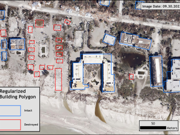
Over the past seven years, researchers in ORNL’s Geospatial Science and Human Security Division have mapped and characterized all structures within the United States and its territories to aid FEMA in its response to disasters. This dataset provides a consistent, nationwide accounting of the buildings where people reside and work.
![LandScan Global depicts population distribution estimates across the planet. The darker orange and red colors above indicate higher population density. Credit: ORNL, U.S. Dept. of Energy](/sites/default/files/styles/list_page_thumbnail/public/2022-05/Picture1_0.jpg?h=9d172ced&itok=uYwYp-pW)
It’s a simple premise: To truly improve the health, safety, and security of human beings, you must first understand where those individuals are.
![ORNL, VA and Harvard researchers developed a sparse matrix full of anonymized information on what is thought to be the largest cohort of healthcare data used for this type of research in the U.S. The matrix can be probed with different methods, such as KESER, to gain new insights into human health. Credit: Nathan Armistead/ORNL, U.S. Dept. of Energy](/sites/default/files/styles/list_page_thumbnail/public/2022-04/2022-G00330_KESER%20Illustration_0.jpg?h=1cb48fc4&itok=c6ZuDdDg)
A team of researchers has developed a novel, machine learning–based technique to explore and identify relationships among medical concepts using electronic health record data across multiple healthcare providers.
![ORNL scientists created a new microbial trait mapping process that improves on classical protoplast fusion techniques to identify the genes that trigger desirable genetic traits like improved biomass processing. Credit: Nathan Armistead/ORNL, U.S. Dept. of Energy. Reprinted with the permission of Oxford University Press, publisher of Nucleic Acids Research](/sites/default/files/styles/list_page_thumbnail/public/2022-04/Nucleic%20Cover%20Illustration.jpg?h=4a9d1e17&itok=iw81emAt)
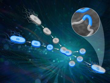
ORNL scientists had a problem mapping the genomes of bacteria to better understand the origins of their physical traits and improve their function for bioenergy production.
![Six ORNL scientists have been elected as fellows to the American Association for the Advancement of Science, or AAAS. Credit: ORNL, U.S. Dept. of Energy](/sites/default/files/styles/list_page_thumbnail/public/2020-11/AAASfellows.jpg?h=d761c044&itok=opKRkA17)
Six ORNL scientists have been elected as fellows to the American Association for the Advancement of Science, or AAAS.
![The CrossVis application includes a parallel coordinates plot (left), a tiled image view (right) and other interactive data views. Credit: Chad Steed/Oak Ridge National Laboratory, U.S. Dept. of Energy](/sites/default/files/styles/list_page_thumbnail/public/2020-07/CrossVisOverview_2.png?h=fd2b4cf7&itok=Mz8wRoMo)
From materials science and earth system modeling to quantum information science and cybersecurity, experts in many fields run simulations and conduct experiments to collect the abundance of data necessary for scientific progress.
![Recent research involving Oak Ridge National Laboratory’s Spallation Neutron Source demonstrates crystal-like heat conduction in a solid-liquid hybrid, AgCrSe2.](/sites/default/files/styles/list_page_thumbnail/public/2020-05/NIEDZELA_PNAS_graphic_0.png?h=39b94f55&itok=CA3sJhdS)
Research by an international team led by Duke University and the Department of Energy’s Oak Ridge National Laboratory scientists could speed the way to safer rechargeable batteries for consumer electronics such as laptops and cellphones.
![A new computational approach by ORNL can more quickly scan large-scale satellite images, such as these of Puerto Rico, for more accurate mapping of complex infrastructure like buildings. Credit: Maxar Technologies and Dalton Lunga/Oak Ridge National Laboratory, U.S. Dept. of Energy](/sites/default/files/styles/list_page_thumbnail/public/2020-02/Puerto_Rico_Resflow9.png?h=a0a1befd&itok=5n2fss_e)
A novel approach developed by scientists at ORNL can scan massive datasets of large-scale satellite images to more accurately map infrastructure – such as buildings and roads – in hours versus days.
![early prototype of the optical array developed by Oak Ridge National Laboratory.](/sites/default/files/styles/list_page_thumbnail/public/2019-08/Optical%20array%20tech%20demo_0.jpg?h=2992f284&itok=ahZ9Umui)
IDEMIA Identity & Security USA has licensed an advanced optical array developed at Oak Ridge National Laboratory. The portable technology can be used to help identify individuals in challenging outdoor conditions.
![As part of a preliminary study, ORNL scientists used critical location data collected from Twitter to map the location of certain power outages across the United States.](/sites/default/files/styles/list_page_thumbnail/public/2019-02/PowerOutageTweets_map_0.png?h=6448fdc1&itok=AUit-O2Y)
Gleaning valuable data from social platforms such as Twitter—particularly to map out critical location information during emergencies— has become more effective and efficient thanks to Oak Ridge National Laboratory.