Filter News
Area of Research
- (-) Mathematics (1)
- (-) National Security (3)
- (-) Sensors and Controls (1)
- Advanced Manufacturing (3)
- Biology and Environment (13)
- Building Technologies (2)
- Clean Energy (42)
- Climate and Environmental Systems (1)
- Computational Engineering (2)
- Computer Science (10)
- Electricity and Smart Grid (1)
- Energy Sciences (1)
- Fusion Energy (2)
- Materials (9)
- Materials for Computing (3)
- Quantum information Science (3)
- Supercomputing (18)
News Topics
- (-) Big Data (2)
- (-) Computer Science (3)
- (-) Grid (3)
- (-) Sustainable Energy (1)
- Artificial Intelligence (1)
- Bioenergy (1)
- Biomedical (2)
- Chemical Sciences (1)
- Clean Water (1)
- Climate Change (1)
- Coronavirus (1)
- Cybersecurity (1)
- Energy Storage (3)
- Environment (3)
- Materials (3)
- Materials Science (3)
- Mathematics (1)
- Microscopy (1)
- Nanotechnology (1)
- Neutron Science (23)
- Nuclear Energy (1)
- Physics (1)
- Quantum Science (1)
- Security (1)
- Space Exploration (1)
- Summit (1)
- Transportation (2)
Media Contacts
![Urban climate modeling](/sites/default/files/styles/list_page_thumbnail/public/2021-03/urbanclimate_sized.jpeg?h=0d9d21a1&itok=-ICe9HqY)
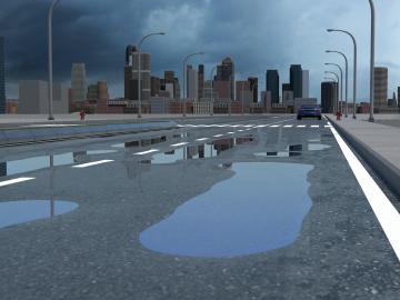
Researchers at Oak Ridge National Laboratory have identified a statistical relationship between the growth of cities and the spread of paved surfaces like roads and sidewalks. These impervious surfaces impede the flow of water into the ground, affecting the water cycle and, by extension, the climate.
![ORNL researchers are developing a method to print low-cost, high-fidelity, customizable sensors for monitoring power grid equipment. Credit: Carlos Jones/ORNL, U.S. Dept. of Energy](/sites/default/files/styles/list_page_thumbnail/public/2021-02/SAW%20sensors%202021-P01084_0.jpg?h=8f9cfe54&itok=H3Fe6A_G)
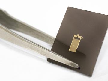
A method developed at Oak Ridge National Laboratory to print high-fidelity, passive sensors for energy applications can reduce the cost of monitoring critical power grid assets.
![A new computational approach by ORNL can more quickly scan large-scale satellite images, such as these of Puerto Rico, for more accurate mapping of complex infrastructure like buildings. Credit: Maxar Technologies and Dalton Lunga/Oak Ridge National Laboratory, U.S. Dept. of Energy](/sites/default/files/styles/list_page_thumbnail/public/2020-02/Puerto_Rico_Resflow9.png?h=a0a1befd&itok=5n2fss_e)
A novel approach developed by scientists at ORNL can scan massive datasets of large-scale satellite images to more accurately map infrastructure – such as buildings and roads – in hours versus days.
![Smart Neighborhood homes](/sites/default/files/styles/list_page_thumbnail/public/2020-01/04.09.TD-SMartHome_0.jpg?h=5b5a5437&itok=22S5Tle1)
To better determine the potential energy cost savings among connected homes, researchers at Oak Ridge National Laboratory developed a computer simulation to more accurately compare energy use on similar weather days.
![As part of a preliminary study, ORNL scientists used critical location data collected from Twitter to map the location of certain power outages across the United States.](/sites/default/files/styles/list_page_thumbnail/public/2019-02/PowerOutageTweets_map_0.png?h=6448fdc1&itok=AUit-O2Y)
Gleaning valuable data from social platforms such as Twitter—particularly to map out critical location information during emergencies— has become more effective and efficient thanks to Oak Ridge National Laboratory.