Two hybrid poplar plants, middle and right, engineered with the PtrXB38 hub gene exhibited a drastic increase in root and callus formation compared with a wild-type control plant, left. Credit: Tao Yao/ORNL, U.S. Dept. of Energy

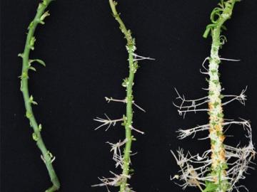
Oak Ridge National Laboratory scientists identified a gene “hotspot” in the poplar tree that triggers dramatically increased root growth. The discovery supports development of better bioenergy crops and other plants that can thrive in difficult conditions while storing more carbon belowground.

Diverse evidence shows that plants and soil will likely capture and hold more carbon in response to increasing levels of carbon dioxide in the atmosphere, according to an analysis published by an international research team led by Oak Ridge National Laboratory.

Diverse evidence shows that plants and soil will likely capture and hold more carbon in response to increasing levels of carbon dioxide in the atmosphere, according to an analysis

Pine trees in the Tuolumne Valley of Yosemite National Park show the effects of drought and fire. Credit: Anthony Walker/Oak Ridge National Laboratory, U.S. Dept. of Energy

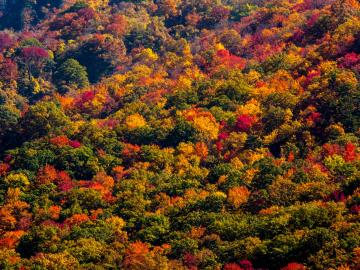
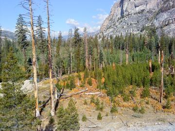
A multi-institutional research team found that changing environmental conditions are affecting forests around the globe, leading to increasing tree death and uncertainty about the ability of forests to recover.

A new computational approach by ORNL can more quickly scan large-scale satellite images, such as these of Puerto Rico, for more accurate mapping of complex infrastructure like buildings. Credit: Maxar Technologies and Dalton Lunga/Oak Ridge National Laboratory, U.S. Dept. of Energy

A novel approach developed by scientists at ORNL can scan massive datasets of large-scale satellite images to more accurately map infrastructure – such as buildings and roads – in hours versus days. 

Heat impact map

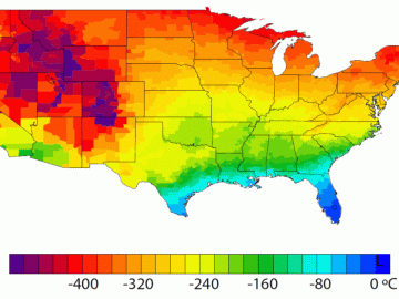
A detailed study by Oak Ridge National Laboratory estimated how much more—or less—energy United States residents might consume by 2050 relative to predicted shifts in seasonal weather patterns 

As part of a preliminary study, ORNL scientists used critical location data collected from Twitter to map the location of certain power outages across the United States.

Gleaning valuable data from social platforms such as Twitter—particularly to map out critical location information during emergencies— has become more effective and efficient thanks to Oak Ridge National Laboratory.