Filter News
Area of Research
- (-) Energy Sciences (1)
- (-) National Security (3)
- Advanced Manufacturing (7)
- Biology and Environment (10)
- Building Technologies (2)
- Clean Energy (40)
- Computational Biology (1)
- Computational Engineering (1)
- Computer Science (6)
- Electricity and Smart Grid (1)
- Fusion and Fission (2)
- Fusion Energy (6)
- Materials (21)
- Materials for Computing (6)
- Neutron Science (3)
- Nuclear Science and Technology (4)
- Quantum information Science (1)
- Sensors and Controls (1)
- Supercomputing (7)
- Transportation Systems (1)
Media Contacts
![ORNL and Enginuity researchers proved that a micro combined heat and power prototype, or mCHP, with an opposed piston engine can achieve more than 93% overall energy efficiency. The environmentally friendly mCHP can replace a back-up generator or traditional hot water heater. Credit: ORNL, U.S. Department of Energy](/sites/default/files/styles/list_page_thumbnail/public/2023-06/storytipjb.png?h=ddb1ad0c&itok=0ZTdSit5)
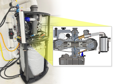
ORNL researchers, in collaboration with Enginuity Power Systems, demonstrated that a micro combined heat and power prototype, or mCHP, with a piston engine can achieve an overall energy efficiency greater than 93%.
![A new computational approach by ORNL can more quickly scan large-scale satellite images, such as these of Puerto Rico, for more accurate mapping of complex infrastructure like buildings. Credit: Maxar Technologies and Dalton Lunga/Oak Ridge National Laboratory, U.S. Dept. of Energy](/sites/default/files/styles/list_page_thumbnail/public/2020-02/Puerto_Rico_Resflow9.png?h=a0a1befd&itok=5n2fss_e)
A novel approach developed by scientists at ORNL can scan massive datasets of large-scale satellite images to more accurately map infrastructure – such as buildings and roads – in hours versus days.
![Smart Neighborhood homes](/sites/default/files/styles/list_page_thumbnail/public/2020-01/04.09.TD-SMartHome_0.jpg?h=5b5a5437&itok=22S5Tle1)
To better determine the potential energy cost savings among connected homes, researchers at Oak Ridge National Laboratory developed a computer simulation to more accurately compare energy use on similar weather days.
![As part of a preliminary study, ORNL scientists used critical location data collected from Twitter to map the location of certain power outages across the United States.](/sites/default/files/styles/list_page_thumbnail/public/2019-02/PowerOutageTweets_map_0.png?h=6448fdc1&itok=AUit-O2Y)
Gleaning valuable data from social platforms such as Twitter—particularly to map out critical location information during emergencies— has become more effective and efficient thanks to Oak Ridge National Laboratory.