Filter News
Area of Research
- (-) National Security (4)
- (-) Transportation Systems (2)
- Advanced Manufacturing (1)
- Biology and Environment (23)
- Clean Energy (47)
- Climate and Environmental Systems (1)
- Computational Biology (1)
- Computational Engineering (2)
- Computer Science (3)
- Fusion and Fission (7)
- Fusion Energy (6)
- Isotopes (3)
- Materials (11)
- Materials for Computing (2)
- Mathematics (1)
- Neutron Science (4)
- Nuclear Science and Technology (3)
- Supercomputing (14)
News Topics
- (-) Big Data (2)
- (-) Climate Change (1)
- (-) Transportation (3)
- 3-D Printing/Advanced Manufacturing (1)
- Artificial Intelligence (2)
- Computer Science (4)
- Coronavirus (1)
- Cybersecurity (5)
- Decarbonization (1)
- Energy Storage (1)
- Environment (1)
- Grid (3)
- Machine Learning (2)
- Materials Science (1)
- National Security (10)
- Nuclear Energy (1)
- Quantum Science (1)
- Security (3)
- Summit (1)
- Sustainable Energy (1)
Media Contacts
![Matt McCarthy uses images collected from the sky to interpret changes to the coastlines and oceans for national security research. Credit: Carlos Jones and Rachel Green/ORNL, U.S. Dept. of Energy](/sites/default/files/styles/list_page_thumbnail/public/2022-08/mccarthy_0.png?h=9d172ced&itok=IRWo-fXz)
When Matt McCarthy saw an opportunity for a young career scientist to influence public policy, he eagerly raised his hand.
![Researchers from ORNL’s Vehicle and Autonomy Research Group created a control strategy for a hybrid electric bus that demonstrated up to 30% energy savings. Credit: University of California, Riverside](/sites/default/files/styles/list_page_thumbnail/public/2021-09/pheb.jpeg?h=4521fff0&itok=nLwLQA4d)
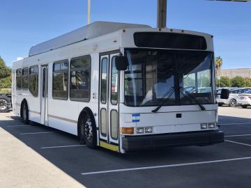
Oak Ridge National Laboratory researchers developed and demonstrated algorithm-based controls for a hybrid electric bus that yielded up to 30% energy savings compared with existing controls.
![A new computational approach by ORNL can more quickly scan large-scale satellite images, such as these of Puerto Rico, for more accurate mapping of complex infrastructure like buildings. Credit: Maxar Technologies and Dalton Lunga/Oak Ridge National Laboratory, U.S. Dept. of Energy](/sites/default/files/styles/list_page_thumbnail/public/2020-02/Puerto_Rico_Resflow9.png?h=a0a1befd&itok=5n2fss_e)
A novel approach developed by scientists at ORNL can scan massive datasets of large-scale satellite images to more accurately map infrastructure – such as buildings and roads – in hours versus days.
![Salting the gears](/sites/default/files/styles/list_page_thumbnail/public/2019-09/Salting-the-gears_1_0.png?h=b00637a2&itok=gsk3DeGh)
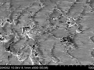
Researchers at Oak Ridge National Laboratory proved that a certain class of ionic liquids, when mixed with commercially available oils, can make gears run more efficiently with less noise and better durability.
![As part of a preliminary study, ORNL scientists used critical location data collected from Twitter to map the location of certain power outages across the United States.](/sites/default/files/styles/list_page_thumbnail/public/2019-02/PowerOutageTweets_map_0.png?h=6448fdc1&itok=AUit-O2Y)
Gleaning valuable data from social platforms such as Twitter—particularly to map out critical location information during emergencies— has become more effective and efficient thanks to Oak Ridge National Laboratory.
![X1800-REED-Maritime Risk Symposium 2018 logo-AM V5-01.jpg X1800-REED-Maritime Risk Symposium 2018 logo-AM V5-01.jpg](/sites/default/files/styles/list_page_thumbnail/public/X1800-REED-Maritime%20Risk%20Symposium%202018%20logo-AM%20V5-01.jpg?itok=_AN4HV63)
Thought leaders from across the maritime community came together at Oak Ridge National Laboratory to explore the emerging new energy landscape for the maritime transportation system during the Ninth Annual Maritime Risk Symposium.