


Craig Blue, Defense Manufacturing Program Director at the Department of Energy’s Oak Ridge National Laboratory, was recently elected to a two-year term on the Institute for Advanced Composites Manufacturing Innovation Consortium Council, a body of professionals from academia, state governments, and national laboratories that provides strategic direction and oversight to IACMI.

Laboratory Director Thomas Zacharia presented five Director’s Awards during Saturday night's annual Awards Night event hosted by UT-Battelle, which manages ORNL for the Department of Energy.
ORNL scientists will present new technologies available for licensing during the annual Technology Innovation Showcase. The event is 9 a.m. to 3 p.m. Thursday, June 16, at the Manufacturing Demonstration Facility at ORNL’s Hardin Valley campus.
An analysis published in the Proceedings of the National Academy of Sciences and led by researchers from the U.S. Department of Energy’s Oak Ridge National Laboratory has received the 2021 Sustainability Science Award from the Ecological Society of America.

Six ORNL scientists have been elected as fellows to the American Association for the Advancement of Science, or AAAS.

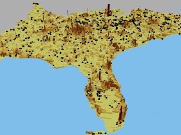
A novel approach developed by scientists at ORNL can scan massive datasets of large-scale satellite images to more accurately map infrastructure – such as buildings and roads – in hours versus days.