![White car (Porsche Taycan) with the hood popped is inside the building with an american flag on the wall.](/sites/default/files/styles/featured_square_large/public/2024-06/2024-P09317.jpg?h=8f9cfe54&itok=m6sQhZRq)
Filter News
Area of Research
- (-) National Security (24)
- Advanced Manufacturing (19)
- Biological Systems (1)
- Biology and Environment (56)
- Building Technologies (1)
- Clean Energy (103)
- Computational Biology (1)
- Computational Engineering (3)
- Computer Science (7)
- Fusion and Fission (5)
- Fusion Energy (3)
- Isotope Development and Production (1)
- Isotopes (18)
- Materials (91)
- Materials Characterization (1)
- Materials for Computing (14)
- Materials Under Extremes (1)
- Mathematics (1)
- Neutron Science (31)
- Nuclear Science and Technology (7)
- Quantum information Science (2)
- Supercomputing (56)
- Transportation Systems (1)
News Type
News Topics
- (-) 3-D Printing/Advanced Manufacturing (2)
- (-) Artificial Intelligence (8)
- (-) Bioenergy (1)
- (-) Biomedical (1)
- (-) Cybersecurity (14)
- (-) Frontier (1)
- (-) Materials Science (1)
- (-) Summit (1)
- Advanced Reactors (1)
- Big Data (2)
- Biology (2)
- Chemical Sciences (2)
- Climate Change (2)
- Computer Science (12)
- Coronavirus (1)
- Energy Storage (2)
- Environment (2)
- Exascale Computing (1)
- Fusion (1)
- Grid (4)
- High-Performance Computing (1)
- Machine Learning (6)
- Materials (1)
- National Security (21)
- Neutron Science (2)
- Nuclear Energy (3)
- Partnerships (4)
- Physics (1)
- Quantum Science (1)
- Security (8)
- Sustainable Energy (2)
- Transportation (2)
Media Contacts
![A new computational approach by ORNL can more quickly scan large-scale satellite images, such as these of Puerto Rico, for more accurate mapping of complex infrastructure like buildings. Credit: Maxar Technologies and Dalton Lunga/Oak Ridge National Laboratory, U.S. Dept. of Energy](/sites/default/files/styles/list_page_thumbnail/public/2020-02/Puerto_Rico_Resflow9.png?h=a0a1befd&itok=5n2fss_e)
A novel approach developed by scientists at ORNL can scan massive datasets of large-scale satellite images to more accurately map infrastructure – such as buildings and roads – in hours versus days.
![Dalton Lunga](/sites/default/files/styles/list_page_thumbnail/public/2020-01/Dalton_Lunga.jpg?h=4dcbbf6e&itok=0FQ-t5EF)
A typhoon strikes an island in the Pacific Ocean, downing power lines and cell towers. An earthquake hits a remote mountainous region, destroying structures and leaving no communication infrastructure behind.
![St John's CyberForce team](/sites/default/files/styles/list_page_thumbnail/public/2019-11/Cyberforce-CroppedStJohnsDec2018_0.jpg?h=d23b96dd&itok=lSiev61W)
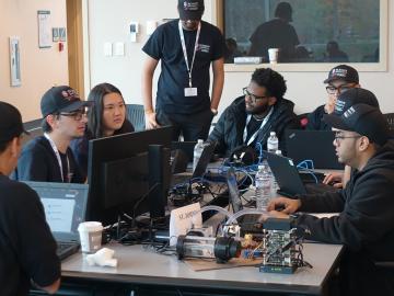
Oak Ridge National Laboratory will give college students the chance to practice cybersecurity skills in a real-world setting as a host of the Department of Energy’s fifth collegiate CyberForce Competition on Nov. 16. The event brings together student teams from across the country to compete at 10 of DOE’s national laboratories.
![early prototype of the optical array developed by Oak Ridge National Laboratory.](/sites/default/files/styles/list_page_thumbnail/public/2019-08/Optical%20array%20tech%20demo_0.jpg?h=2992f284&itok=ahZ9Umui)
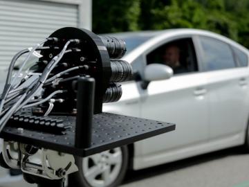
IDEMIA Identity & Security USA has licensed an advanced optical array developed at Oak Ridge National Laboratory. The portable technology can be used to help identify individuals in challenging outdoor conditions.