![White car (Porsche Taycan) with the hood popped is inside the building with an american flag on the wall.](/sites/default/files/styles/featured_square_large/public/2024-06/2024-P09317.jpg?h=8f9cfe54&itok=m6sQhZRq)
Filter News
Area of Research
- (-) National Security (13)
- (-) Quantum information Science (4)
- Advanced Manufacturing (18)
- Biology and Environment (32)
- Building Technologies (2)
- Clean Energy (76)
- Climate and Environmental Systems (2)
- Computational Biology (1)
- Computational Engineering (3)
- Computer Science (12)
- Fusion and Fission (1)
- Fusion Energy (3)
- Isotopes (2)
- Materials (45)
- Materials for Computing (7)
- Mathematics (1)
- Neutron Science (19)
- Nuclear Science and Technology (4)
- Supercomputing (58)
News Type
News Topics
- (-) 3-D Printing/Advanced Manufacturing (1)
- (-) Big Data (2)
- (-) Climate Change (1)
- (-) Computer Science (14)
- (-) Physics (2)
- (-) Summit (1)
- Advanced Reactors (1)
- Artificial Intelligence (6)
- Bioenergy (1)
- Biology (2)
- Biomedical (1)
- Chemical Sciences (2)
- Coronavirus (1)
- Cybersecurity (12)
- Energy Storage (2)
- Environment (2)
- Exascale Computing (1)
- Frontier (1)
- Fusion (1)
- Grid (4)
- High-Performance Computing (1)
- Machine Learning (4)
- Materials (1)
- Materials Science (1)
- National Security (11)
- Neutron Science (2)
- Nuclear Energy (2)
- Partnerships (4)
- Quantum Science (4)
- Security (6)
- Sustainable Energy (2)
- Transportation (2)
Media Contacts
![A new computational approach by ORNL can more quickly scan large-scale satellite images, such as these of Puerto Rico, for more accurate mapping of complex infrastructure like buildings. Credit: Maxar Technologies and Dalton Lunga/Oak Ridge National Laboratory, U.S. Dept. of Energy](/sites/default/files/styles/list_page_thumbnail/public/2020-02/Puerto_Rico_Resflow9.png?h=a0a1befd&itok=5n2fss_e)
A novel approach developed by scientists at ORNL can scan massive datasets of large-scale satellite images to more accurately map infrastructure – such as buildings and roads – in hours versus days.
![Smart Neighborhood homes](/sites/default/files/styles/list_page_thumbnail/public/2020-01/04.09.TD-SMartHome_0.jpg?h=5b5a5437&itok=22S5Tle1)
To better determine the potential energy cost savings among connected homes, researchers at Oak Ridge National Laboratory developed a computer simulation to more accurately compare energy use on similar weather days.
![St John's CyberForce team](/sites/default/files/styles/list_page_thumbnail/public/2019-11/Cyberforce-CroppedStJohnsDec2018_0.jpg?h=d23b96dd&itok=lSiev61W)
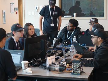
Oak Ridge National Laboratory will give college students the chance to practice cybersecurity skills in a real-world setting as a host of the Department of Energy’s fifth collegiate CyberForce Competition on Nov. 16. The event brings together student teams from across the country to compete at 10 of DOE’s national laboratories.
![quantum mechanics to advance a range of technologies including computing, fiber optics and network communication](/sites/default/files/styles/list_page_thumbnail/public/2019-09/2017-P08412_0.jpg?h=b6236d98&itok=ecQNon31)
Three researchers at Oak Ridge National Laboratory will lead or participate in collaborative research projects aimed at harnessing the power of quantum mechanics to advance a range of technologies including computing, fiber optics and network
![Quantum—Widening the net](/sites/default/files/styles/list_page_thumbnail/public/2019-06/2018-P04780_0.jpg?h=c6980913&itok=IRxCZtUy)
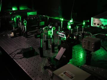
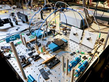
Scientists at Oak Ridge National Laboratory studying quantum communications have discovered a more practical way to share secret messages among three parties, which could ultimately lead to better cybersecurity for the electric grid
![Quantum—Squeezed light cuts noise](/sites/default/files/styles/list_page_thumbnail/public/2019-06/Quantum-Squeezed_light_cuts_noise_0.jpg?h=557ecedc&itok=dbeUQ4mY)
Oak Ridge National Laboratory physicists studying quantum sensing, which could impact a wide range of potential applications from airport security scanning to gravitational wave measurements, have outlined in ACS Photonics the dramatic advances in the field.
![As part of a preliminary study, ORNL scientists used critical location data collected from Twitter to map the location of certain power outages across the United States.](/sites/default/files/styles/list_page_thumbnail/public/2019-02/PowerOutageTweets_map_0.png?h=6448fdc1&itok=AUit-O2Y)
Gleaning valuable data from social platforms such as Twitter—particularly to map out critical location information during emergencies— has become more effective and efficient thanks to Oak Ridge National Laboratory.