Filter News
Area of Research
- (-) Climate and Environmental Systems (1)
- (-) National Security (5)
- Advanced Manufacturing (4)
- Biology and Environment (17)
- Building Technologies (2)
- Clean Energy (68)
- Computational Engineering (2)
- Computer Science (12)
- Electricity and Smart Grid (2)
- Energy Sciences (2)
- Functional Materials for Energy (2)
- Fusion and Fission (3)
- Fusion Energy (2)
- Isotopes (2)
- Materials (32)
- Materials for Computing (6)
- Mathematics (1)
- Neutron Science (6)
- Quantum information Science (4)
- Sensors and Controls (1)
- Supercomputing (27)
News Type
News Topics
- (-) Big Data (2)
- (-) Computer Science (4)
- (-) Energy Storage (1)
- (-) Grid (2)
- (-) Physics (1)
- (-) Sustainable Energy (1)
- Advanced Reactors (1)
- Bioenergy (1)
- Biology (2)
- Climate Change (2)
- Coronavirus (1)
- Cybersecurity (3)
- Environment (4)
- Fusion (1)
- Materials Science (1)
- National Security (4)
- Neutron Science (2)
- Nuclear Energy (2)
- Partnerships (1)
- Security (2)
- Summit (1)
- Transportation (1)
Media Contacts
![A group of people standing outside in front of trees and buildings](/sites/default/files/styles/list_page_thumbnail/public/2022-11/2022-P10952.jpg?h=8f9cfe54&itok=Wd2coEC5)
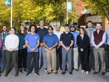
Nine student physicists and engineers from the #1-ranked Nuclear Engineering and Radiological Sciences Program at the University of Michigan, or UM, attended a scintillation detector workshop at Oak Ridge National Laboratory Oct. 10-13.
![Six ORNL scientists have been elected as fellows to the American Association for the Advancement of Science, or AAAS. Credit: ORNL, U.S. Dept. of Energy](/sites/default/files/styles/list_page_thumbnail/public/2020-11/AAASfellows.jpg?h=d761c044&itok=opKRkA17)
Six ORNL scientists have been elected as fellows to the American Association for the Advancement of Science, or AAAS.
![A new computational approach by ORNL can more quickly scan large-scale satellite images, such as these of Puerto Rico, for more accurate mapping of complex infrastructure like buildings. Credit: Maxar Technologies and Dalton Lunga/Oak Ridge National Laboratory, U.S. Dept. of Energy](/sites/default/files/styles/list_page_thumbnail/public/2020-02/Puerto_Rico_Resflow9.png?h=a0a1befd&itok=5n2fss_e)
A novel approach developed by scientists at ORNL can scan massive datasets of large-scale satellite images to more accurately map infrastructure – such as buildings and roads – in hours versus days.
![Smart Neighborhood homes](/sites/default/files/styles/list_page_thumbnail/public/2020-01/04.09.TD-SMartHome_0.jpg?h=5b5a5437&itok=22S5Tle1)
To better determine the potential energy cost savings among connected homes, researchers at Oak Ridge National Laboratory developed a computer simulation to more accurately compare energy use on similar weather days.
![Heat impact map](/sites/default/files/styles/list_page_thumbnail/public/2019-07/Winter_HDD_Change_ORNL.gif?h=e87b941e&itok=8t83D_u_)
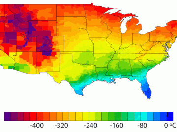
A detailed study by Oak Ridge National Laboratory estimated how much more—or less—energy United States residents might consume by 2050 relative to predicted shifts in seasonal weather patterns
![As part of a preliminary study, ORNL scientists used critical location data collected from Twitter to map the location of certain power outages across the United States.](/sites/default/files/styles/list_page_thumbnail/public/2019-02/PowerOutageTweets_map_0.png?h=6448fdc1&itok=AUit-O2Y)
Gleaning valuable data from social platforms such as Twitter—particularly to map out critical location information during emergencies— has become more effective and efficient thanks to Oak Ridge National Laboratory.