Filter News
Area of Research
- (-) Electricity and Smart Grid (2)
- (-) National Security (12)
- Advanced Manufacturing (2)
- Biology and Environment (39)
- Clean Energy (65)
- Climate and Environmental Systems (4)
- Computational Engineering (2)
- Computer Science (12)
- Functional Materials for Energy (1)
- Fusion and Fission (11)
- Fusion Energy (8)
- Isotopes (1)
- Materials (31)
- Materials for Computing (3)
- Mathematics (1)
- Neutron Science (14)
- Nuclear Science and Technology (6)
- Quantum information Science (5)
- Sensors and Controls (1)
- Supercomputing (38)
News Type
News Topics
- (-) Artificial Intelligence (7)
- (-) Environment (3)
- (-) Fusion (1)
- (-) Grid (5)
- (-) Machine Learning (5)
- 3-D Printing/Advanced Manufacturing (1)
- Advanced Reactors (1)
- Big Data (2)
- Bioenergy (1)
- Biology (2)
- Biomedical (1)
- Buildings (1)
- Chemical Sciences (2)
- Climate Change (1)
- Computer Science (10)
- Coronavirus (1)
- Cybersecurity (11)
- Decarbonization (1)
- Energy Storage (3)
- Exascale Computing (1)
- Frontier (2)
- High-Performance Computing (2)
- Materials (2)
- Materials Science (2)
- National Security (11)
- Neutron Science (2)
- Nuclear Energy (3)
- Partnerships (4)
- Physics (1)
- Security (6)
- Simulation (1)
- Summit (1)
- Sustainable Energy (3)
- Transportation (2)
Media Contacts
![A new computational approach by ORNL can more quickly scan large-scale satellite images, such as these of Puerto Rico, for more accurate mapping of complex infrastructure like buildings. Credit: Maxar Technologies and Dalton Lunga/Oak Ridge National Laboratory, U.S. Dept. of Energy](/sites/default/files/styles/list_page_thumbnail/public/2020-02/Puerto_Rico_Resflow9.png?h=a0a1befd&itok=5n2fss_e)
A novel approach developed by scientists at ORNL can scan massive datasets of large-scale satellite images to more accurately map infrastructure – such as buildings and roads – in hours versus days.
![Smart Neighborhood homes](/sites/default/files/styles/list_page_thumbnail/public/2020-01/04.09.TD-SMartHome_0.jpg?h=5b5a5437&itok=22S5Tle1)
To better determine the potential energy cost savings among connected homes, researchers at Oak Ridge National Laboratory developed a computer simulation to more accurately compare energy use on similar weather days.
![early prototype of the optical array developed by Oak Ridge National Laboratory.](/sites/default/files/styles/list_page_thumbnail/public/2019-08/Optical%20array%20tech%20demo_0.jpg?h=2992f284&itok=ahZ9Umui)
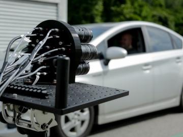
IDEMIA Identity & Security USA has licensed an advanced optical array developed at Oak Ridge National Laboratory. The portable technology can be used to help identify individuals in challenging outdoor conditions.
![As part of a preliminary study, ORNL scientists used critical location data collected from Twitter to map the location of certain power outages across the United States.](/sites/default/files/styles/list_page_thumbnail/public/2019-02/PowerOutageTweets_map_0.png?h=6448fdc1&itok=AUit-O2Y)
Gleaning valuable data from social platforms such as Twitter—particularly to map out critical location information during emergencies— has become more effective and efficient thanks to Oak Ridge National Laboratory.