


A new tool from Oak Ridge National Laboratory can help planners, emergency responders and scientists visualize how flood waters will spread for any scenario and terrain.

From materials science and earth system modeling to quantum information science and cybersecurity, experts in many fields run simulations and conduct experiments to collect the abundance of data necessary for scientific progress.
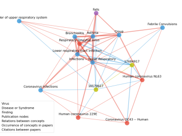
Scientists have tapped the immense power of the Summit supercomputer at Oak Ridge National Laboratory to comb through millions of medical journal articles to identify potential vaccines, drugs and effective measures that could suppress or stop the

In the race to identify solutions to the COVID-19 pandemic, researchers at the Department of Energy’s Oak Ridge National Laboratory are joining the fight by applying expertise in computational science, advanced manufacturing, data science and neutron science.

A novel approach developed by scientists at ORNL can scan massive datasets of large-scale satellite images to more accurately map infrastructure – such as buildings and roads – in hours versus days.

Students often participate in internships and receive formal training in their chosen career fields during college, but some pursue professional development opportunities even earlier.

A team of scientists led by Oak Ridge National Laboratory used machine learning methods to generate a high-resolution map of vegetation growing in the remote reaches of the Alaskan tundra.

The field of “Big Data” has exploded in the blink of an eye, growing exponentially into almost every branch of science in just a few decades. Sectors such as energy, manufacturing, healthcare and many others depend on scalable data processing and analysis for continued in...