


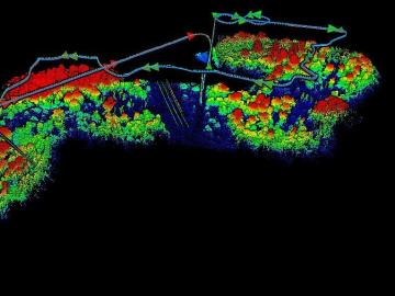
The Autonomous Systems group at ORNL is in high demand as it incorporates remote sensing into projects needing a bird’s-eye perspective.
Zheng Gai, a senior staff scientist at ORNL’s Center for Nanophase Materials Sciences, has been selected as editor-in-chief of the Spin Crossover and Spintronics section of Magnetochemistry.

Six ORNL scientists have been elected as fellows to the American Association for the Advancement of Science, or AAAS.

From materials science and earth system modeling to quantum information science and cybersecurity, experts in many fields run simulations and conduct experiments to collect the abundance of data necessary for scientific progress.

Research by an international team led by Duke University and the Department of Energy’s Oak Ridge National Laboratory scientists could speed the way to safer rechargeable batteries for consumer electronics such as laptops and cellphones.

A novel approach developed by scientists at ORNL can scan massive datasets of large-scale satellite images to more accurately map infrastructure – such as buildings and roads – in hours versus days.