Filter News
Area of Research
News Topics
- (-) Environment (1)
- (-) Isotopes (1)
- (-) Nanotechnology (1)
- (-) Neutron Science (1)
- 3-D Printing/Advanced Manufacturing (1)
- Advanced Reactors (2)
- Big Data (1)
- Biomedical (2)
- Computer Science (2)
- Coronavirus (1)
- Energy Storage (1)
- Grid (1)
- Materials Science (1)
- Molten Salt (1)
- Nuclear Energy (3)
- Summit (1)
- Sustainable Energy (1)
Media Contacts
![Shown here is an on-chip carbonized electrode microstructure from a scanning electron microscope. Credit: ORNL, U.S. Dept. of Energy](/sites/default/files/styles/list_page_thumbnail/public/2020-10/Lavrik%20Story%20Tip_0.jpg?h=33192216&itok=nNMwVUtU)
Scientists at Oak Ridge National Laboratory and the University of Tennessee designed and demonstrated a method to make carbon-based materials that can be used as electrodes compatible with a specific semiconductor circuitry.
![Solid radium sulfate sits in the bottom of a flask during the recovery process. Credit: Oak Ridge National Laboratory, U.S. Dept. of Energy](/sites/default/files/styles/list_page_thumbnail/public/2020-06/Ac227%202.jpg?h=479d286c&itok=AiNceGva)
Oak Ridge National Laboratory researchers have discovered a better way to separate actinium-227, a rare isotope essential for an FDA-approved cancer treatment.
![Nuclear — Seeing inside particles](/sites/default/files/styles/list_page_thumbnail/public/2020-04/Kernels-nuclear%20materials-2_0.jpg?h=ae51ec69&itok=_AWiopZz)
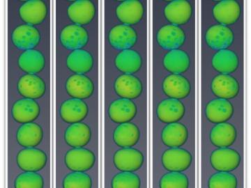
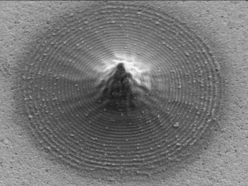
Oak Ridge National Laboratory researchers working on neutron imaging capabilities for nuclear materials have developed a process for seeing the inside of uranium particles – without cutting them open.
![A new computational approach by ORNL can more quickly scan large-scale satellite images, such as these of Puerto Rico, for more accurate mapping of complex infrastructure like buildings. Credit: Maxar Technologies and Dalton Lunga/Oak Ridge National Laboratory, U.S. Dept. of Energy](/sites/default/files/styles/list_page_thumbnail/public/2020-02/Puerto_Rico_Resflow9.png?h=a0a1befd&itok=5n2fss_e)
A novel approach developed by scientists at ORNL can scan massive datasets of large-scale satellite images to more accurately map infrastructure – such as buildings and roads – in hours versus days.