
Polyphase wireless power transfer system achieves 270-kilowatt charge, s...
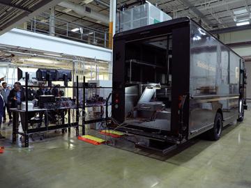
Researchers at the Department of Energy’s Oak Ridge National Laboratory (ORNL) in late February demonstrated a 20-kilowatt bi-directional wireless charging system installed on a UPS medium-duty, plug-in hybrid electric delivery truck.
Each year, approximately 6 billion gallons of fuel are wasted as vehicles wait at stop lights or sit in dense traffic with engines idling, according to US Department of Energy estimates.

A novel approach developed by scientists at ORNL can scan massive datasets of large-scale satellite images to more accurately map infrastructure – such as buildings and roads – in hours versus days.
