![White car (Porsche Taycan) with the hood popped is inside the building with an american flag on the wall.](/sites/default/files/styles/featured_square_large/public/2024-06/2024-P09317.jpg?h=8f9cfe54&itok=m6sQhZRq)
Filter News
Area of Research
News Topics
- (-) 3-D Printing/Advanced Manufacturing (1)
- (-) Environment (7)
- (-) Machine Learning (3)
- (-) Microscopy (1)
- (-) Transportation (4)
- Artificial Intelligence (1)
- Big Data (3)
- Biology (2)
- Biomedical (4)
- Climate Change (5)
- Computer Science (6)
- Coronavirus (2)
- Energy Storage (6)
- Frontier (1)
- Fusion (1)
- Grid (3)
- Materials Science (3)
- Polymers (2)
- Summit (3)
- Sustainable Energy (8)
Media Contacts
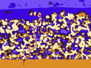
An international team of scientists found that rules governing plant growth hold true even at the edges of the world in the Arctic tundra.
![Batteries - The 3D connection](/sites/default/files/styles/list_page_thumbnail/public/2020-05/Batteries_3D%20story%20tip_2.jpg?h=aeb34e32&itok=puhZ_584)
Oak Ridge National Laboratory researchers have developed a thin film, highly conductive solid-state electrolyte made of a polymer and ceramic-based composite for lithium metal batteries.
![Wireless charging – Special delivery for UPS](/sites/default/files/styles/list_page_thumbnail/public/2020-05/UPS_wireless_power_story%20tip_3000.jpg?h=3748d94f&itok=Xf2MDLEi)
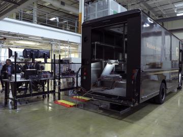
Researchers at Oak Ridge National Laboratory demonstrated a 20-kilowatt bi-directional wireless charging system on a UPS plug-in hybrid electric delivery truck, advancing the technology to a larger class of vehicles and enabling a new energy storage method for fleet owners and their facilities.
![A new computational approach by ORNL can more quickly scan large-scale satellite images, such as these of Puerto Rico, for more accurate mapping of complex infrastructure like buildings. Credit: Maxar Technologies and Dalton Lunga/Oak Ridge National Laboratory, U.S. Dept. of Energy](/sites/default/files/styles/list_page_thumbnail/public/2020-02/Puerto_Rico_Resflow9.png?h=a0a1befd&itok=5n2fss_e)
A novel approach developed by scientists at ORNL can scan massive datasets of large-scale satellite images to more accurately map infrastructure – such as buildings and roads – in hours versus days.