Filter News
Area of Research
News Topics
- (-) 3-D Printing/Advanced Manufacturing (1)
- (-) Big Data (1)
- (-) Coronavirus (2)
- (-) Machine Learning (2)
- (-) Polymers (1)
- (-) Summit (1)
- Climate Change (3)
- Computer Science (2)
- Energy Storage (6)
- Environment (4)
- Grid (3)
- Materials Science (3)
- Microscopy (1)
- Neutron Science (4)
- Nuclear Energy (1)
- Sustainable Energy (7)
- Transportation (4)
Media Contacts
![3D printed EMPOWER wall drawing](/sites/default/files/styles/list_page_thumbnail/public/2020-08/EMP_WALL11.jpg?h=1d9512c1&itok=3Q-UnrTY)
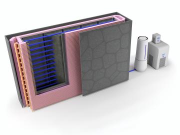
Oak Ridge National Laboratory researchers used additive manufacturing to build a first-of-its kind smart wall called EMPOWER.
![Cars and coronavirus](/sites/default/files/styles/list_page_thumbnail/public/2020-08/Transportation-Gauging_pandemic_impact_ORNL_0.jpg?h=4a7d1ed4&itok=Xqx4kknO)
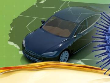
Oak Ridge National Laboratory researchers have developed a machine learning model that could help predict the impact pandemics such as COVID-19 have on fuel demand in the United States.
![Map with focus on sub-saharan Africa](/sites/default/files/styles/list_page_thumbnail/public/2020-07/firms3-Africa-NASA_0.jpg?h=27f1d52b&itok=G8uUS5cH)
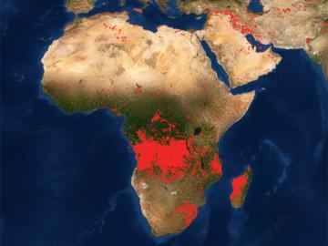
Researchers at Oak Ridge National Laboratory developed a method that uses machine learning to predict seasonal fire risk in Africa, where half of the world’s wildfire-related carbon emissions originate.
![Batteries - The 3D connection](/sites/default/files/styles/list_page_thumbnail/public/2020-05/Batteries_3D%20story%20tip_2.jpg?h=aeb34e32&itok=puhZ_584)
Oak Ridge National Laboratory researchers have developed a thin film, highly conductive solid-state electrolyte made of a polymer and ceramic-based composite for lithium metal batteries.
![GIS – LandScan goes public](/sites/default/files/styles/list_page_thumbnail/public/2020-05/sanfran%20%281%29_2.png?h=ea18fbc4&itok=c_VbFqAC)
Oak Ridge National Laboratory’s high-resolution population distribution database, LandScan USA, became permanently available to researchers in time to aid the response to the novel coronavirus pandemic.
![A new computational approach by ORNL can more quickly scan large-scale satellite images, such as these of Puerto Rico, for more accurate mapping of complex infrastructure like buildings. Credit: Maxar Technologies and Dalton Lunga/Oak Ridge National Laboratory, U.S. Dept. of Energy](/sites/default/files/styles/list_page_thumbnail/public/2020-02/Puerto_Rico_Resflow9.png?h=a0a1befd&itok=5n2fss_e)
A novel approach developed by scientists at ORNL can scan massive datasets of large-scale satellite images to more accurately map infrastructure – such as buildings and roads – in hours versus days.