Filter News
Area of Research
- (-) National Security (4)
- (-) Quantum information Science (2)
- Biology and Environment (4)
- Building Technologies (1)
- Clean Energy (16)
- Computational Engineering (1)
- Computer Science (4)
- Electricity and Smart Grid (1)
- Fusion and Fission (7)
- Fusion Energy (3)
- Materials (5)
- Materials for Computing (4)
- Mathematics (1)
- Neutron Science (3)
- Nuclear Science and Technology (2)
- Sensors and Controls (1)
- Supercomputing (11)
Media Contacts
![ORNL’s particle entanglement machine is a precursor to the device that researchers at the University of Oklahoma are building, which will produce entangled quantum particles for quantum sensing to detect underground pipeline leaks. Credit: ORNL, U.S. Dept. of Energy](/sites/default/files/styles/list_page_thumbnail/public/2021-07/IMG_20170706_154618586AK_0.jpg?h=61873cd7&itok=0OWbsNbu)
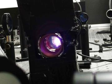
To minimize potential damage from underground oil and gas leaks, Oak Ridge National Laboratory is co-developing a quantum sensing system to detect pipeline leaks more quickly.
![Six ORNL scientists have been elected as fellows to the American Association for the Advancement of Science, or AAAS. Credit: ORNL, U.S. Dept. of Energy](/sites/default/files/styles/list_page_thumbnail/public/2020-11/AAASfellows.jpg?h=d761c044&itok=opKRkA17)
Six ORNL scientists have been elected as fellows to the American Association for the Advancement of Science, or AAAS.
![Kübra Yeter-Aydeniz](/sites/default/files/styles/list_page_thumbnail/public/2020-09/yeter.jpg?h=252f27fa&itok=hfxJWutl)
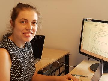
Kübra Yeter-Aydeniz, a postdoctoral researcher, was recently named the Turkish Women in Science group’s “Scientist of the Week.”
![GIS – LandScan goes public](/sites/default/files/styles/list_page_thumbnail/public/2020-05/sanfran%20%281%29_2.png?h=ea18fbc4&itok=c_VbFqAC)
Oak Ridge National Laboratory’s high-resolution population distribution database, LandScan USA, became permanently available to researchers in time to aid the response to the novel coronavirus pandemic.
![A new computational approach by ORNL can more quickly scan large-scale satellite images, such as these of Puerto Rico, for more accurate mapping of complex infrastructure like buildings. Credit: Maxar Technologies and Dalton Lunga/Oak Ridge National Laboratory, U.S. Dept. of Energy](/sites/default/files/styles/list_page_thumbnail/public/2020-02/Puerto_Rico_Resflow9.png?h=a0a1befd&itok=5n2fss_e)
A novel approach developed by scientists at ORNL can scan massive datasets of large-scale satellite images to more accurately map infrastructure – such as buildings and roads – in hours versus days.
![Smart Neighborhood homes](/sites/default/files/styles/list_page_thumbnail/public/2020-01/04.09.TD-SMartHome_0.jpg?h=5b5a5437&itok=22S5Tle1)
To better determine the potential energy cost savings among connected homes, researchers at Oak Ridge National Laboratory developed a computer simulation to more accurately compare energy use on similar weather days.