Filter News
Area of Research
News Topics
- (-) Big Data (3)
- (-) Molten Salt (1)
- 3-D Printing/Advanced Manufacturing (2)
- Advanced Reactors (6)
- Artificial Intelligence (1)
- Biology (2)
- Biomedical (6)
- Climate Change (5)
- Computer Science (7)
- Coronavirus (3)
- Energy Storage (7)
- Environment (8)
- Frontier (1)
- Fusion (3)
- Grid (3)
- Isotopes (1)
- Machine Learning (3)
- Materials Science (8)
- Microscopy (2)
- Nanotechnology (2)
- Neutron Science (4)
- Nuclear Energy (6)
- Polymers (2)
- Summit (3)
- Sustainable Energy (8)
- Transportation (4)
Media Contacts
![Data collection instruments at the North Pole](/sites/default/files/styles/list_page_thumbnail/public/2020-11/49464270498_a1ff680b23_o_0.jpg?h=8afd2337&itok=zh9gntwP)
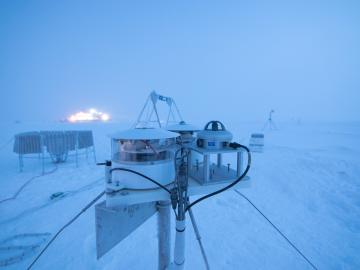
Researchers at Oak Ridge National Laboratory were part of an international team that collected a treasure trove of data measuring precipitation, air particles, cloud patterns and the exchange of energy between the atmosphere and the sea ice.
![Computing – Mining for COVID-19 connections](/sites/default/files/styles/list_page_thumbnail/public/2020-05/pubmedconnections-covid-19-2_0.png?h=3dbd9eac&itok=NPdQ3tCD)
Scientists have tapped the immense power of the Summit supercomputer at Oak Ridge National Laboratory to comb through millions of medical journal articles to identify potential vaccines, drugs and effective measures that could suppress or stop the
![Nuclear – Finally, a benchmark](/sites/default/files/styles/list_page_thumbnail/public/2020-05/67051_0.jpg?h=add82d74&itok=xR-EnPtz)
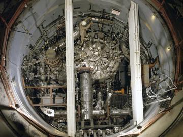
In the 1960s, Oak Ridge National Laboratory's four-year Molten Salt Reactor Experiment tested the viability of liquid fuel reactors for commercial power generation. Results from that historic experiment recently became the basis for the first-ever molten salt reactor benchmark.
![A new computational approach by ORNL can more quickly scan large-scale satellite images, such as these of Puerto Rico, for more accurate mapping of complex infrastructure like buildings. Credit: Maxar Technologies and Dalton Lunga/Oak Ridge National Laboratory, U.S. Dept. of Energy](/sites/default/files/styles/list_page_thumbnail/public/2020-02/Puerto_Rico_Resflow9.png?h=a0a1befd&itok=5n2fss_e)
A novel approach developed by scientists at ORNL can scan massive datasets of large-scale satellite images to more accurately map infrastructure – such as buildings and roads – in hours versus days.