Fungi use signaling molecules called LCOs to communicate with each other and to regulate growth. Credit: Jessy Labbe/Oak Ridge National Laboratory, U.S. Dept. of Energy

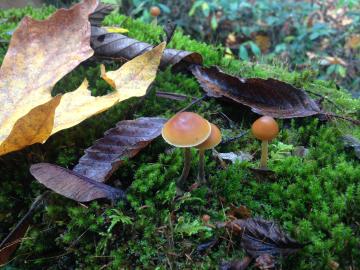
Oak Ridge National Laboratory and collaborators have discovered that signaling molecules known to trigger symbiosis between plants and soil bacteria are also used by almost all fungi as chemical signals to communicate with each other.

Diverse evidence shows that plants and soil will likely capture and hold more carbon in response to increasing levels of carbon dioxide in the atmosphere, according to an analysis published by an international research team led by Oak Ridge National Laboratory.

Diverse evidence shows that plants and soil will likely capture and hold more carbon in response to increasing levels of carbon dioxide in the atmosphere, according to an analysis

Data collection instruments at the North Pole

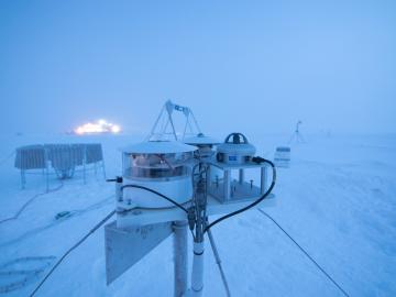
Researchers at Oak Ridge National Laboratory were part of an international team that collected a treasure trove of data measuring precipitation, air particles, cloud patterns and the exchange of energy between the atmosphere and the sea ice.

Pine trees in the Tuolumne Valley of Yosemite National Park show the effects of drought and fire. Credit: Anthony Walker/Oak Ridge National Laboratory, U.S. Dept. of Energy

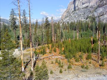
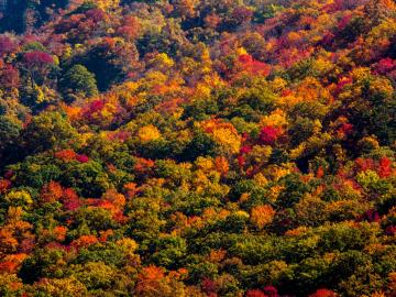
A multi-institutional research team found that changing environmental conditions are affecting forests around the globe, leading to increasing tree death and uncertainty about the ability of forests to recover.

Nuclear — Seeing inside particles

Oak Ridge National Laboratory researchers working on neutron imaging capabilities for nuclear materials have developed a process for seeing the inside of uranium particles – without cutting them open.

A new computational approach by ORNL can more quickly scan large-scale satellite images, such as these of Puerto Rico, for more accurate mapping of complex infrastructure like buildings. Credit: Maxar Technologies and Dalton Lunga/Oak Ridge National Laboratory, U.S. Dept. of Energy

A novel approach developed by scientists at ORNL can scan massive datasets of large-scale satellite images to more accurately map infrastructure – such as buildings and roads – in hours versus days.