ORNL researchers are establishing a digital thread of data, algorithms and workflows to produce a continuously updated model of earth systems.

Digital twins are exactly what they sound like: virtual models of physical reality that continuously update to reflect changes in the real world.


Sam Hollifield displays a prototype of the Secure Hijack, Intrusion and Exploit Layered Detector, or SHIELD, the device monitoring the cybersecurity of the semi-truck. Credit: Lena Shoemaker/ORNL, U.S. Dept. of Energy

As vehicles gain technological capabilities, car manufacturers are using an increasing number of computers and sensors to improve situational awareness and enhance the driving experience.

A LiDAR survey of a local stream collected from one of ORNL’s drones. Credit: Andrew Duncan/ORNL, U.S. Dept. of Energy

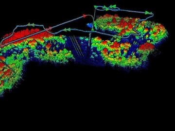
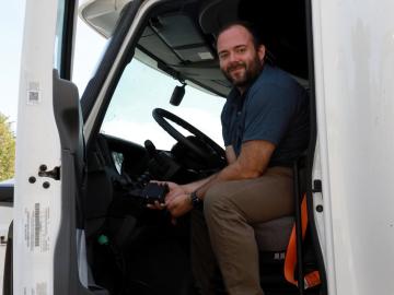
The Autonomous Systems group at ORNL is in high demand as it incorporates remote sensing into projects needing a bird’s-eye perspective.

Six ORNL scientists have been elected as fellows to the American Association for the Advancement of Science, or AAAS. Credit: ORNL, U.S. Dept. of Energy

Six ORNL scientists have been elected as fellows to the American Association for the Advancement of Science, or AAAS.

The CrossVis application includes a parallel coordinates plot (left), a tiled image view (right) and other interactive data views. Credit: Chad Steed/Oak Ridge National Laboratory, U.S. Dept. of Energy

From materials science and earth system modeling to quantum information science and cybersecurity, experts in many fields run simulations and conduct experiments to collect the abundance of data necessary for scientific progress.

Recent research involving Oak Ridge National Laboratory’s Spallation Neutron Source demonstrates crystal-like heat conduction in a solid-liquid hybrid, AgCrSe2.

Research by an international team led by Duke University and the Department of Energy’s Oak Ridge National Laboratory scientists could speed the way to safer rechargeable batteries for consumer electronics such as laptops and cellphones.

A new computational approach by ORNL can more quickly scan large-scale satellite images, such as these of Puerto Rico, for more accurate mapping of complex infrastructure like buildings. Credit: Maxar Technologies and Dalton Lunga/Oak Ridge National Laboratory, U.S. Dept. of Energy

A novel approach developed by scientists at ORNL can scan massive datasets of large-scale satellite images to more accurately map infrastructure – such as buildings and roads – in hours versus days.