Filter News
Area of Research
- (-) National Security (2)
- Advanced Manufacturing (2)
- Biology and Environment (44)
- Clean Energy (46)
- Climate and Environmental Systems (2)
- Computational Biology (1)
- Computational Engineering (2)
- Fusion and Fission (1)
- Isotopes (3)
- Materials (7)
- Materials for Computing (3)
- Mathematics (1)
- Neutron Science (10)
- Nuclear Science and Technology (3)
- Quantum information Science (1)
- Supercomputing (21)
News Type
News Topics
- (-) Environment (2)
- Advanced Reactors (3)
- Artificial Intelligence (2)
- Big Data (2)
- Climate Change (1)
- Computer Science (9)
- Coronavirus (1)
- Cybersecurity (6)
- Energy Storage (1)
- Frontier (1)
- Fusion (4)
- Grid (1)
- Machine Learning (1)
- Materials Science (3)
- Nanotechnology (1)
- National Security (6)
- Neutron Science (2)
- Nuclear Energy (5)
- Quantum Science (1)
- Security (4)
- Summit (2)
- Sustainable Energy (2)
Media Contacts
![ORNL Image](/sites/default/files/styles/list_page_thumbnail/public/SE_elec_consumption_withPplants.jpg?h=50ec1d8e&itok=SqxQDFw8)
An analysis published in the Proceedings of the National Academy of Sciences and led by researchers from the U.S. Department of Energy’s Oak Ridge National Laboratory has received the 2021 Sustainability Science Award from the Ecological Society of America.
![A new computational approach by ORNL can more quickly scan large-scale satellite images, such as these of Puerto Rico, for more accurate mapping of complex infrastructure like buildings. Credit: Maxar Technologies and Dalton Lunga/Oak Ridge National Laboratory, U.S. Dept. of Energy](/sites/default/files/styles/list_page_thumbnail/public/2020-02/Puerto_Rico_Resflow9.png?h=a0a1befd&itok=5n2fss_e)
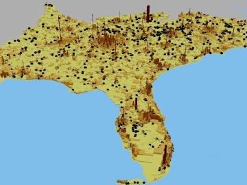
A novel approach developed by scientists at ORNL can scan massive datasets of large-scale satellite images to more accurately map infrastructure – such as buildings and roads – in hours versus days.