![White car (Porsche Taycan) with the hood popped is inside the building with an american flag on the wall.](/sites/default/files/styles/featured_square_large/public/2024-06/2024-P09317.jpg?h=8f9cfe54&itok=m6sQhZRq)
Filter News
Area of Research
- (-) Supercomputing (16)
- Advanced Manufacturing (4)
- Biology and Environment (5)
- Clean Energy (36)
- Climate and Environmental Systems (3)
- Computational Engineering (1)
- Computer Science (6)
- Fusion and Fission (1)
- Fusion Energy (6)
- Isotopes (1)
- Materials (15)
- Materials for Computing (1)
- National Security (5)
- Neutron Science (9)
- Nuclear Science and Technology (15)
- Nuclear Systems Modeling, Simulation and Validation (1)
- Quantum information Science (4)
News Topics
- (-) Environment (5)
- (-) Grid (2)
- (-) Machine Learning (2)
- (-) Nuclear Energy (2)
- (-) Quantum Science (7)
- 3-D Printing/Advanced Manufacturing (3)
- Advanced Reactors (1)
- Artificial Intelligence (4)
- Big Data (4)
- Bioenergy (5)
- Biology (1)
- Biomedical (6)
- Chemical Sciences (1)
- Climate Change (1)
- Computer Science (26)
- Coronavirus (4)
- Cybersecurity (2)
- Decarbonization (1)
- Energy Storage (2)
- Exascale Computing (1)
- Frontier (3)
- Fusion (1)
- High-Performance Computing (1)
- Isotopes (1)
- Materials (2)
- Materials Science (5)
- Microscopy (2)
- Molten Salt (1)
- Nanotechnology (3)
- National Security (1)
- Neutron Science (6)
- Physics (2)
- Polymers (1)
- Security (1)
- Space Exploration (1)
- Summit (13)
- Sustainable Energy (6)
- Transportation (3)
Media Contacts
![A new computational approach by ORNL can more quickly scan large-scale satellite images, such as these of Puerto Rico, for more accurate mapping of complex infrastructure like buildings. Credit: Maxar Technologies and Dalton Lunga/Oak Ridge National Laboratory, U.S. Dept. of Energy](/sites/default/files/styles/list_page_thumbnail/public/2020-02/Puerto_Rico_Resflow9.png?h=a0a1befd&itok=5n2fss_e)
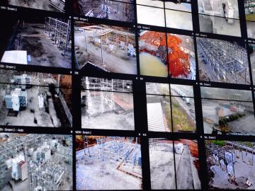
A novel approach developed by scientists at ORNL can scan massive datasets of large-scale satellite images to more accurately map infrastructure – such as buildings and roads – in hours versus days.
![The Sycamore quantum processor. Credit: Erik Lucero/Google](/sites/default/files/styles/list_page_thumbnail/public/2019-10/Google_AI_Quantum_Sycamore_Erik_Lucero.png?h=4a7d1ed4&itok=MKR_1dTp)
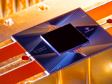
A joint research team from Google Inc., NASA Ames Research Center, and the Department of Energy’s Oak Ridge National Laboratory has demonstrated that a quantum computer can outperform a classical computer
![Pictured in this early conceptual drawing, the Translational Research Capability planned for Oak Ridge National Laboratory will follow the design of research facilities constructed during the laboratory’s modernization campaign.](/sites/default/files/styles/list_page_thumbnail/public/2019-05/TRCimage.jpg?h=2ee3f751&itok=9rywjcFh)
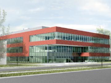
OAK RIDGE, Tenn., May 7, 2019—Energy Secretary Rick Perry, Congressman Chuck Fleischmann and lab officials today broke ground on a multipurpose research facility that will provide state-of-the-art laboratory space
![Small modular reactor computer simulation](/sites/default/files/styles/list_page_thumbnail/public/2019-04/Nuclear_simulation_scale-up.jpg?h=5992a83f&itok=A0oscIPL)
In a step toward advancing small modular nuclear reactor designs, scientists at Oak Ridge National Laboratory have run reactor simulations on ORNL supercomputer Summit with greater-than-expected computational efficiency.
OAK RIDGE, Tenn., Feb. 12, 2019—A team of researchers from the Department of Energy’s Oak Ridge and Los Alamos National Laboratories has partnered with EPB, a Chattanooga utility and telecommunications company, to demonstrate the effectiveness of metro-scale quantum key distribution (QKD).
![Researchers used machine learning methods on the ORNL Compute and Data Environment for Science, or CADES, to map vegetation communities in the Kougarok Watershed on the Seward Peninsula of Alaska. The colors denote different types of vegetation, such as w Researchers used machine learning methods on the ORNL Compute and Data Environment for Science, or CADES, to map vegetation communities in the Kougarok Watershed on the Seward Peninsula of Alaska. The colors denote different types of vegetation, such as w](/sites/default/files/styles/list_page_thumbnail/public/rs2019_highlight_plot_3d.png?itok=5bROV_ys)
A team of scientists led by Oak Ridge National Laboratory used machine learning methods to generate a high-resolution map of vegetation growing in the remote reaches of the Alaskan tundra.