


A novel approach developed by scientists at ORNL can scan massive datasets of large-scale satellite images to more accurately map infrastructure – such as buildings and roads – in hours versus days.
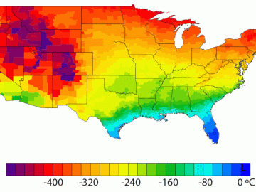
A detailed study by Oak Ridge National Laboratory estimated how much more—or less—energy United States residents might consume by 2050 relative to predicted shifts in seasonal weather patterns

Thought leaders from across the maritime community came together at Oak Ridge National Laboratory to explore the emerging new energy landscape for the maritime transportation system during the Ninth Annual Maritime Risk Symposium.