ORNL will use its land surface modeling tools to determine Baltimore’s climate risk and analyze green infrastructure improvements that can help mitigate impacts on underserved communities as part of a DOE Urban Integrated Field Laboratory project. Source: Google Earth, accessed Sept. 12, 2022

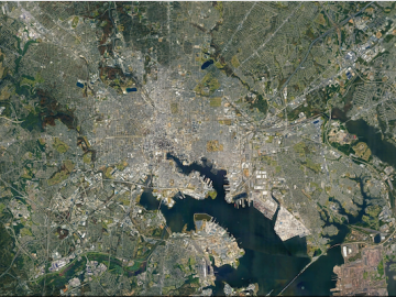
ORNL researchers are deploying their broad expertise in climate data and modeling to create science-based mitigation strategies for cities stressed by climate change as part of two U.S. Department of Energy Urban Integrated Field Laboratory projects.

ORNL, VA and Harvard researchers developed a sparse matrix full of anonymized information on what is thought to be the largest cohort of healthcare data used for this type of research in the U.S. The matrix can be probed with different methods, such as KESER, to gain new insights into human health. Credit: Nathan Armistead/ORNL, U.S. Dept. of Energy

A team of researchers has developed a novel, machine learning–based  technique to explore and identify relationships among medical concepts using electronic health record data across multiple healthcare providers.

The Energy Exascale Earth System Model project reliably simulates aspects of earth system variability and projects decadal changes that will critically impact the U.S. energy sector in the future. A new version of the model delivers twice the performance of its predecessor. Credit: E3SM, Dept. of Energy

A new version of the Energy Exascale Earth System Model, or E3SM, is two times faster than an earlier version released in 2018.

This protein drives key processes for sulfide use in many microorganisms that produce methane, including Thermosipho melanesiensis. Researchers used supercomputing and deep learning tools to predict its structure, which has eluded experimental methods such as crystallography.  Credit: Ada Sedova/ORNL, U.S. Dept. of Energy

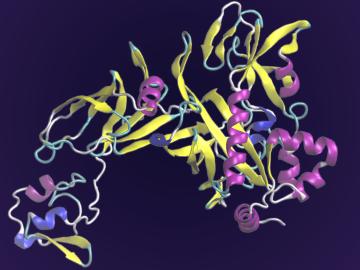
A team of scientists led by the Department of Energy’s Oak Ridge National Laboratory and the Georgia Institute of Technology is using supercomputing and revolutionary deep learning tools to predict the structures and roles of thousands of proteins with unknown functions.

The students analyzed diatom images like this one to compare wild and genetically modified strains of these organisms. Credit: Alison Pawlicki/Oak Ridge National Laboratory, US Department of Energy.

Students often participate in internships and receive formal training in their chosen career fields during college, but some pursue professional development opportunities even earlier.

Snapshot of total temperature distribution at supersonic speed of mach 2.4. Total temperature allows the team to visualize the extent of the exhaust plumes as the temperature of the plumes is much greater than that of the surrounding atmosphere. Credit: NASA

The type of vehicle that will carry people to the Red Planet is shaping up to be “like a two-story house you’re trying to land on another planet. 

Galactic wind simulation

Using the Titan supercomputer at Oak Ridge National Laboratory, a team of astrophysicists created a set of galactic wind simulations of the highest resolution ever performed. The simulations will allow researchers to gather and interpret more accurate, detailed data that elucidates how galactic winds affect the formation and evolution of galaxies.

Laminations such as these are compiled to form the core of modern electric vehicle motors. ORNL has developed a software toolkit to speed the development of new motor designs and to improve the accuracy of their real-world performance.

Oak Ridge National Laboratory scientists have created open source software that scales up analysis of motor designs to run on the fastest computers available, including those accessible to outside users at the Oak Ridge Leadership Computing Facility.

Researchers used machine learning methods on the ORNL Compute and Data Environment for Science, or CADES, to map vegetation communities in the Kougarok Watershed on the Seward Peninsula of Alaska. The colors denote different types of vegetation, such as w

A team of scientists led by Oak Ridge National Laboratory used machine learning methods to generate a high-resolution map of vegetation growing in the remote reaches of the Alaskan tundra.