ORNL will use its land surface modeling tools to determine Baltimore’s climate risk and analyze green infrastructure improvements that can help mitigate impacts on underserved communities as part of a DOE Urban Integrated Field Laboratory project. Source: Google Earth, accessed Sept. 12, 2022

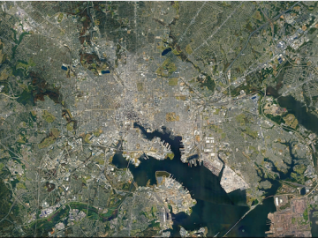
ORNL researchers are deploying their broad expertise in climate data and modeling to create science-based mitigation strategies for cities stressed by climate change as part of two U.S. Department of Energy Urban Integrated Field Laboratory projects.

Researchers used quantum Monte Carlo calculations to accurately render the structure and electronic properties of germanium selenide, a semiconducting nanomaterial. Credit: Paul Kent/ORNL, U.S. Dept. of Energy

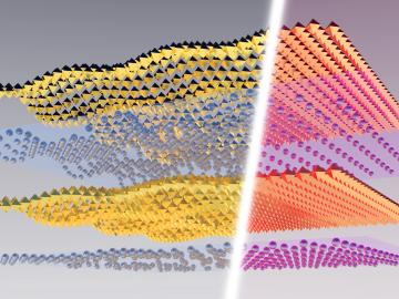
A multi-lab research team led by ORNL's Paul Kent is developing a computer application called QMCPACK to enable precise and reliable predictions of the fundamental properties of materials critical in energy research.

Sophie Voisin, an ORNL software engineer, was part of a team that won a 2014 R&D 100 Award for work on Intelligent Software for a Personalized Modeling of Expert Opinions, Decisions and Errors in Visual Examination Tasks. Credit: Jason Richards/ORNL, U.S. Dept. of Energy

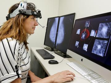
Cameras see the world differently than humans. Resolution, equipment, lighting, distance and atmospheric conditions can impact how a person interprets objects on a photo.

Data from different sources are joined on platforms created by ORNL researchers to offer better information for decision makers. Credit: ORNL/Nathan Armistead

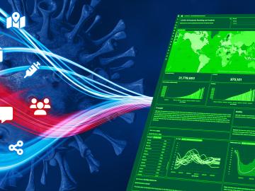
When the COVID-19 pandemic stunned the world in 2020, researchers at ORNL wondered how they could extend their support and help
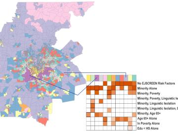
ORNL scientists created a geodemographic cluster for the Atlanta metro area that identifies risk factors related to climate impacts. Credit: ORNL/U.S. Dept. of Energy

A new capability to identify urban neighborhoods, down to the block and building level, that are most vulnerable to climate change could help ensure that mitigation and resilience programs reach the people who need them the most.

LandScan Global depicts population distribution estimates across the planet. The darker orange and red colors above indicate higher population density. Credit: ORNL, U.S. Dept. of Energy

It’s a simple premise: To truly improve the health, safety, and security of human beings, you must first understand where those individuals are.

ORNL, VA and Harvard researchers developed a sparse matrix full of anonymized information on what is thought to be the largest cohort of healthcare data used for this type of research in the U.S. The matrix can be probed with different methods, such as KESER, to gain new insights into human health. Credit: Nathan Armistead/ORNL, U.S. Dept. of Energy

A team of researchers has developed a novel, machine learning–based  technique to explore and identify relationships among medical concepts using electronic health record data across multiple healthcare providers.

Earth Day

Tackling the climate crisis and achieving an equitable clean energy future are among the biggest challenges of our time. 

This image illustrates lattice distortion, strain, and ion distribution in metal halide perovskites, which can be induced by external stimuli such as light and heat. Image credit: Stephen Jesse/ORNL

A study by researchers at the ORNL takes a fresh look at what could become the first step toward a new generation of solar batteries.

The Energy Exascale Earth System Model project reliably simulates aspects of earth system variability and projects decadal changes that will critically impact the U.S. energy sector in the future. A new version of the model delivers twice the performance of its predecessor. Credit: E3SM, Dept. of Energy

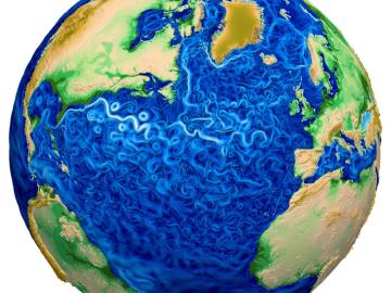
A new version of the Energy Exascale Earth System Model, or E3SM, is two times faster than an earlier version released in 2018.