Michelle Kidder received the lab’s Director’s Award for Outstanding Individual Accomplishment in Science and Technology for her decades-long work mentoring students, teachers and early-career staff. Credit: Carlos Jones/ORNL, U.S. Dept. of Energy

Laboratory Director Thomas Zacharia presented five Director’s Awards during Saturday night's annual Awards Night event hosted by UT-Battelle, which manages ORNL for the Department of Energy.

This image from Sept. 30, 2022, shows how the Federal Emergency Management Agency used ORNL's USA Structures data along with new satellite images to identify structures that were destroyed in Lee County, Florida, during Hurricane Ian. Credit: ORNL, U.S. Dept. of Energy

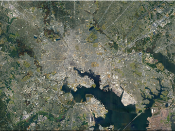
Over the past seven years, researchers in ORNL’s Geospatial Science and Human Security Division have mapped and characterized all structures within the United States and its territories to aid FEMA in its response to disasters. This dataset provides a consistent, nationwide accounting of the buildings where people reside and work.

ORNL will use its land surface modeling tools to determine Baltimore’s climate risk and analyze green infrastructure improvements that can help mitigate impacts on underserved communities as part of a DOE Urban Integrated Field Laboratory project. Source: Google Earth, accessed Sept. 12, 2022

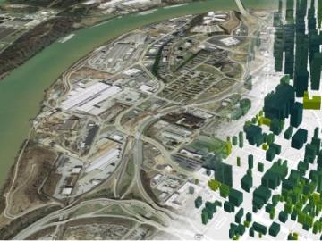
ORNL researchers are deploying their broad expertise in climate data and modeling to create science-based mitigation strategies for cities stressed by climate change as part of two U.S. Department of Energy Urban Integrated Field Laboratory projects.

Oak Ridge National Laboratory’s software suite AutoBEM is being used in the architecture, city planning, real estate and home efficiency industries. Users take advantage of the suite’s energy modeling of almost all U.S. buildings. Credit: ORNL, U.S. Dept. of Energy

Two years after ORNL provided a model of nearly every building in America, commercial partners are using the tool for tasks ranging from designing energy-efficient buildings and cities to linking energy efficiency to real estate value and risk.

Researchers used quantum Monte Carlo calculations to accurately render the structure and electronic properties of germanium selenide, a semiconducting nanomaterial. Credit: Paul Kent/ORNL, U.S. Dept. of Energy

A multi-lab research team led by ORNL's Paul Kent is developing a computer application called QMCPACK to enable precise and reliable predictions of the fundamental properties of materials critical in energy research.

Matt McCarthy uses images collected from the sky to interpret changes to the coastlines and oceans for national security research. Credit: Carlos Jones and Rachel Green/ORNL, U.S. Dept. of Energy

When Matt McCarthy saw an opportunity for a young career scientist to influence public policy, he eagerly raised his hand.

Sophie Voisin, an ORNL software engineer, was part of a team that won a 2014 R&D 100 Award for work on Intelligent Software for a Personalized Modeling of Expert Opinions, Decisions and Errors in Visual Examination Tasks. Credit: Jason Richards/ORNL, U.S. Dept. of Energy

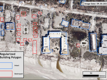
Cameras see the world differently than humans. Resolution, equipment, lighting, distance and atmospheric conditions can impact how a person interprets objects on a photo.

Data from different sources are joined on platforms created by ORNL researchers to offer better information for decision makers. Credit: ORNL/Nathan Armistead

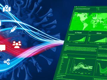
When the COVID-19 pandemic stunned the world in 2020, researchers at ORNL wondered how they could extend their support and help

Scattering-type scanning near-field optical microscopy, a nondestructive technique in which the tip of the probe of a microscope scatters pulses of light to generate a picture of a sample, allowed the team to obtain insights into the composition of plant cell walls. Credit: Ali Passian/ORNL, U.S. Dept. of Energy

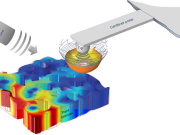
To optimize biomaterials for reliable, cost-effective paper production, building construction, and biofuel development, researchers often study the structure of plant cells using techniques such as freezing plant samples or placing them in a vacuum.
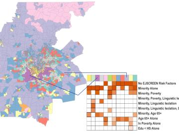
ORNL scientists created a geodemographic cluster for the Atlanta metro area that identifies risk factors related to climate impacts. Credit: ORNL/U.S. Dept. of Energy

A new capability to identify urban neighborhoods, down to the block and building level, that are most vulnerable to climate change could help ensure that mitigation and resilience programs reach the people who need them the most.