
Quantum precision reached in modeling molten salt behavior

Jack Orebaugh, a forensic anthropology major at the University of Tennessee, Knoxville, has a big heart for families with missing loved ones. When someone disappears in an area of dense vegetation, search and recovery efforts can be difficult, especially when a missing person’s last location is unknown. Recognizing the agony of not knowing what happened to a family or friend, Orebaugh decided to use his internship at the Department of Energy’s Oak Ridge National Laboratory to find better ways to search for lost and deceased people using cameras and drones.
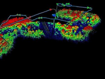
The Autonomous Systems group at ORNL is in high demand as it incorporates remote sensing into projects needing a bird’s-eye perspective.
Natural gas furnaces not only heat your home, they also produce a lot of pollution. Even modern high-efficiency condensing furnaces produce significant amounts of corrosive acidic condensation and unhealthy levels of nitrogen oxides

Paul Langan will join ORNL in the spring as associate laboratory director for the Biological and Environmental Systems Science Directorate.
Laboratory Director Thomas Zacharia presented five Director’s Awards during Saturday night's annual Awards Night event hosted by UT-Battelle, which manages ORNL for the Department of Energy.
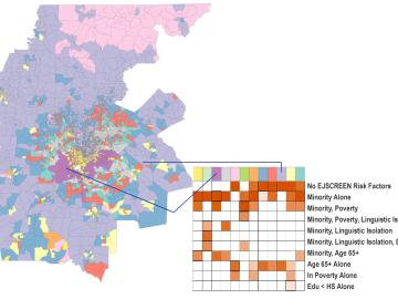
A new capability to identify urban neighborhoods, down to the block and building level, that are most vulnerable to climate change could help ensure that mitigation and resilience programs reach the people who need them the most.
An analysis published in the Proceedings of the National Academy of Sciences and led by researchers from the U.S. Department of Energy’s Oak Ridge National Laboratory has received the 2021 Sustainability Science Award from the Ecological Society of America.

Scientists at ORNL used neutron scattering and supercomputing to better understand how an organic solvent and water work together to break down plant biomass, creating a pathway to significantly improve the production of renewable

The Department of Energy’s Office of Science has selected three Oak Ridge National Laboratory scientists for Early Career Research Program awards.
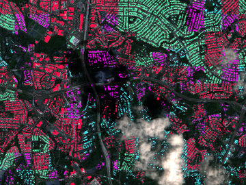
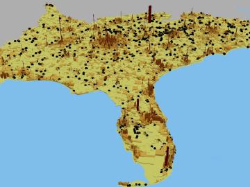
A novel approach developed by scientists at ORNL can scan massive datasets of large-scale satellite images to more accurately map infrastructure – such as buildings and roads – in hours versus days.
