CalFires.png

As hurricanes barrel toward the coastlines and wildfires rage in arid regions of the United States, scientists at the Department of Energy’s Oak Ridge National Laboratory are providing critical geospatial data to support first responders as they work to save lives and property.

Jay Jay Billings and Alex McCaskey observe visualizations of ICE simulation data on ORNL’s Exploratory Visualization Environment for Research in Science and Technology facility. Credit: Jason Richards/ORNL
Since designing and launching a specialized workflow management system in 2010, a research team from the U.S. Department of Energy’s Oak Ridge National Laboratory has continuously updated the technology to help computational scientists develop software, visualize data and solve ...
Singanallur “Venkat” Venkatakrishnan is a Wigner Fellow in the Imaging, Signals, and Machine Learning Group at ORNL.
Singanallur “Venkat” Venkatakrishnan is helping scientists get a better view of objects under study by some of Oak Ridge National Laboratory’s most powerful instruments by creating algorithms that turn data into 3D renderings with fewer images. The result is a better understanding o...
The ORNL-developed site assessment tool, dubbed SMH Explorer, provides a platform to develop small modular hydropower technologies by identifying common physical and environmental characteristics in stream segments across the nation. Credit: Oak Ridge Nat

Oak Ridge National Laboratory has created new tools to better understand the nation’s waterways and identify potential sites to generate hydropower—a domestic renewable energy resource. The tools allow users such as scientists, resource agencies and industry to access information ab...

Researchers at Oak Ridge National Laboratory contributed buildings and structures datasets to the Federal Emergency Management Agency to support emergency response following major volcanic eruptions on the Island of Hawaii.
Geospatial data from Oak Ridge National Laboratory is supporting emergency response to destructive volcanic activity in Hawaii. Researchers provided the Federal Emergency Management Agency with information on buildings and structures that was rapidly extracted from satellite imagery usi...
ORNL Image

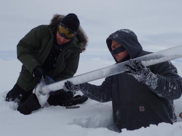
For the past six years, some 140 scientists from five institutions have traveled to the Arctic Circle and beyond to gather field data as part of the Department of Energy-sponsored NGEE Arctic project. This article gives insight into how scientists gather the measurements that inform t...

VehicleIDSensorinCone2.

Algorithms designed to parse data gathered by roadside sensors could make it easier to identify vehicles sought in AMBER Alerts and to assist researchers studying traffic patterns. Oak Ridge National Laboratory scientists built a sensor platform to collect detailed images of cars, as w...

Oak Ridge National Laboratory’s Stacy Davis has a trove of transportation facts and trends at her fingertips.

For anyone seeking comprehensive data and analysis regarding the vehicle technology market, all roads lead to Oak Ridge National Laboratory’s Stacy Davis. Unflagging curiosity, an ability to read trends, and an eagle eye for detail are the tools that drive Davis’s work creatin...

Germina Ilas (left) and Ian Gauld review spent fuel data entries in the SFCOMPO 2.0 database.
Oak Ridge National Laboratory provided significant contributions and coordination in the development of the Nuclear Energy Agency’s (NEA’s) recently released Spent Fuel Isotopic Composition (SFCOMPO) 2.0—the world’s largest open database for spent