
Members and students of the Computational Urban Sciences group demonstrated a method for generating scenarios of urban neighborhood growth based on existing physical structures and placement of buildings in neighborhoods.
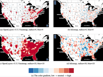
A multidisciplinary team of researchers from Oak Ridge National Laboratory (ORNL) developed a new online heatmap method, named hilomap, to visualize geospatial datasets as online map layers when low and high trends are equally important to map users.