Evaluate the historical performance and future projections of compound heatwave and drought (CHD) extremes across the contiguous United States using CMIP6 global climate models, providing insights for regional adaptation strategies in response to
Evaluate the historical performance and future projections of compound heatwave and drought (CHD) extremes across the contiguous United States using CMIP6 global climate models, providing insights for regional adaptation strategies in response to

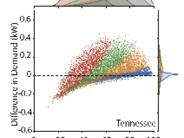
The objective of this study is to explore and analyze the spatial patterning of sociodemographic disparities in extreme heat exposure across multiple scales within the Conterminous United States (CONUS).
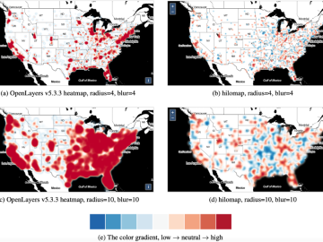
A multidisciplinary team of researchers from Oak Ridge National Laboratory (ORNL) developed a new online heatmap method, named hilomap, to visualize geospatial datasets as online map layers when low and high trends are equally important to map users.

Members and students of the Computational Urban Sciences group demonstrated a method for generating scenarios of urban neighborhood growth based on existing physical structures and placement of buildings in neighborhoods.
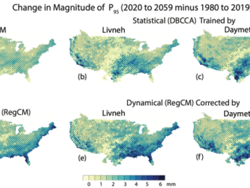
We present an intercomparison of a suite of high-resolution downscaled climate projections based on a six-member General Climate Models (GCM) ensemble from the 6th Phase of Coupled Models Intercomparison Project (CMIP6).
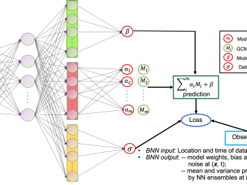
Multimodel ensembling improves predictions and considers model uncertainties. In this study, we present a Bayesian Neural Network (BNN) ensemble approach for large-scale precipitation predictions based on a set of climate models.

Important insights into many data science problems that are traditionally analyzed via statistical models can be obtained by re-formulating and evaluating within a large-scale optimization framework.

Spatial optimization seeks optimal allocation or arrangement of spatial units under constraints such as distance, adjacency, contiguity, and pattern. Evolutionary Algorithms (EAs) are well-known optimization heuristics.