An illustration of the interconnected nature of Intelligent Watersheds. These systems coordinate the actions of interdependent agents that gather, manage, analyze, and respond to information according to their unique community and stakeholder needs. Credit: ORNL, U.S. Dept. of Energy
Overview/Objective
Watersheds play a critical role in supporting energy generation, drinking water supplies, agriculture, and recreation across the nation. Rising demand for these essential services, coupled with environmental changes, is placing unprecedented stress on water resources. In turn the strain on the system is increasing uncertainty and competition for these resources, impacting everything from reservoir operations to river-basin management. Meanwhile, advancements in monitoring, data sharing, supercomputing, modeling, and artificial intelligence offer opportunities to connect data more effectively with decision-making, particularly at the complex watershed scale.
In response to these challenges and opportunities, researchers at Oak Ridge National Laboratory (ORNL) and Pacific Northwest National Laboratory (PNNL)—in collaboration with the Internet of Water Coalition and other key stakeholders—are working to create advanced watershed resource management systems that digitally integrate disparate sources of information. These so-called Intelligent Watersheds will enable smarter, more informed decisions that balance complex and evolving water resource needs.
The project aims to provide hydropower operators, municipalities, and other stakeholders with technical tools and institutional connections that improve system performance and resilience.
Results
During the project period from early 2023 through 2024, the Intelligent Watersheds team completed five key activities:
Data Needs Assessment: Designed and administered a comprehensive questionnaire to identify critical data types relevant to watershed-scale hydropower decisions.
Stakeholder Discussions: Completed 43 expert consultations with professionals involved in hydropower and watershed information, including data collection, management, modeling, and decision-making. These conversations clarified current practices and helped refine the core ideas within watershed intelligence.
Virtual Workshops: Held interactive whiteboard sessions involving more than two dozen stakeholders, who helped identify emerging solutions and priority actions for creating more intelligent watershed systems.
Case Study in Upper Colorado River Basin: Conducted targeted small-group discussions in partnership with the Internet of Water Coalition, mapping data connections and decision pathways within a real-world watershed.
Sharing Early Results: Presented findings and discussed technical and institutional solutions at the American Geophysical Union (AGU) 2023 and 2024 Fall Meetings, and at the Electric Power Research Institute’s (EPRI) Long-term Ecological Change Workshop in November 2024
Impact
These new tools will help hydropower operators more effectively manage competing demands, keeping the public, the environment and the nation’s water infrastructure safe and functional.
Recommendations
To date, the input from industry, government, and research experts has elucidated several key areas of opportunity:
Building on existing intensive monitoring and modeling efforts:Existing initiatives such as the Department of Energy-supported Scientific Focus Areas (SFAs) and the U.S. Geological Survey’s Next Generation Water Observing System (NGWOS) currently provide extensive basin-wide monitoring and modeling. These initiatives could be enhanced by explicitly incorporating regulated systems—such as dams and hydropower facilities—which have traditionally received less attention in basin-scale studies. Integrating these regulated components will significantly expand the effectiveness and applicability of watershed-scale resource management.
Improving Coordination Across the Data-to-Decision Pipeline: Both stakeholders and researchers strongly identified data integration, standardization, and coordination across the data-to-decision process as a major objective. Currently, stakeholders often duplicate efforts by independently collecting, preparing, and analyzing similar datasets. Enhancing cross-sector and inter-agency coordination would significantly streamline efforts, improve accuracy, and increase decision-making efficiency at the watershed level.
Establishing Communities of Practice:Stakeholders supported developing communities of practice that regularly bring together scientists, infrastructure operators, and policymakers. These communities improve communication, and accelerate the adoption of new analytical approaches, tools, and technologies into everyday decision-making processes.
Through these activities, ORNL and PNNL researchers have charted a clear path toward systems capable of delivering practical, actionable intelligence to stakeholders throughout U.S. watersheds.
Collaborators
Internet of Water Coalition: Faith Sternlieb, Amelia Green, Kyle Onda
For more information or to collaborate, please contact ORNL’s Carly Hansen ([email protected]) or PNNL’s Vincent Tidwell ([email protected]).
SECURE Water Act: Section 9505 Assessment
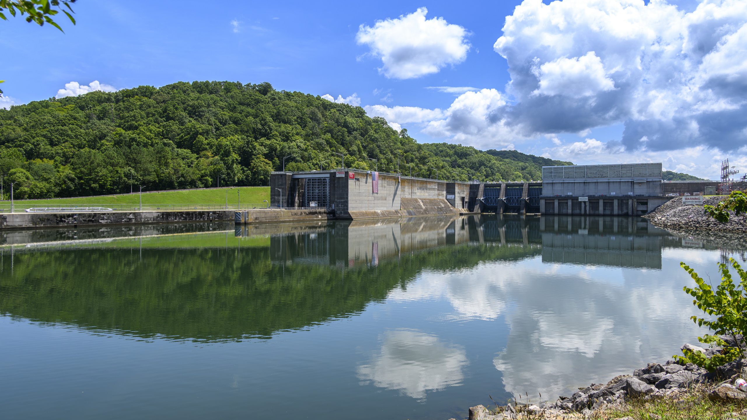
Shasta Dam and Lake in California. Credit: U.S. Bureau of Reclamation
Overview/Objective
Hydropower is a key contributor to the nation’s energy portfolio, helping to fill in the gaps between traditional sources of electricity and intermittent sources such as wind and solar. However, as environmental change results in more extreme weather events across the United States — particularly droughts in the west — it is crucial to better understand and predict the conditions that impact sustainable hydropower electricity generation and what operational changes can be made to mitigate these impacts.
The latest information about how these trends are evolving can be found in a report released by the U.S. Department of Energy’s Oak Ridge National Laboratory, which details its findings from its third environmental change impact assessment for hydropower. The report is part of a series produced during a multi-year study directed by Congress in Section 9505 of the SECURE Water Act (SWA, Public Law 111-11) of 2009.
In consultation with the federal power marketing administrations and other federal agencies, ORNL led a series of assessments for 132 federal hydropower plants across the United States to examine the potential effects of environmental change on water available for hydropower generation and on the marketing of power from these federal facilities. The effort was further expanded to non-federal hydropower fleet to serve the broader hydropower community.
A spatially consistent assessment approach was designed to enable interregional comparisons. This approach used a series of models and methods with different spatial resolutions to gradually downscale global environmental change signals into watershed-scale hydrologic projections to support hydropower impact assessments. In the first of three assessments, a variety of historic meteorologic and hydrologic observations, hydropower facility characteristics and geospatial data sets were collected to support model development, calibration and verification. The second assessment provided future seasonal and monthly hydropower projections to support long-term hydropower marketing planning. Finally, the third assessment adopted a multi-model assessment framework to better reveal the uncertainties in future hydrologic and hydropower projections. During each assessment, the latest environmental projection information from the Coupled Model Intercomparison Project was used to support the modeling and analysis.
Several potential risks that may impact the resilience of future federal hydropower generation were identified:
Hydrologic extremes continue to intensify. The intensification of future hydrologic cycle and extreme events was found to be one of the most critical issues threatening the resilience of power systems and infrastructure. Both historical observations and model projections suggest the intensity, frequency and magnitude of extreme rainfall events will continue to increase, which will likely challenge conventional reservoir management practices. Furthermore, the duration and severity of extreme drought events are also projected to increase in many parts of the United States. The ongoing megadrought in the western U.S. resulted in an unprecedented disruption to the water supply and hydropower generation, demonstrating the dire impacts of drought.
The timing of available supply and peak demand is increasingly coming into conflict. Temperature-driven early snowmelt is projected in most of the western U.S., suggesting the bulk of runoff may arrive earlier in the spring. However, as informed by the energy demand analysis, more temperature-driven water and energy demand is expected to shift from winter to summer, which creates a conflict. Although, ideally, one may expect to mitigate this conflict through reservoir management, the intensified hydrologic extremes combined with all other competing water management objectives will limit the ability and flexibility to store more water resources to meet peak demand. Furthermore, in arid regions, the enhanced reservoir evaporation may result in a sizable reduction in storage and further exacerbate the nexus of electricity demand and water availability.
Overall, the results suggest that maintaining operational flexibility remains a key challenge for federal hydropower reservoirs. Although long-term average annual runoff and hydropower generation are projected to slightly increase across the United States, the uncertainty in the projections is large and suggests less runoff and generation in some seasons and regions. Increasing operational and marketing flexibilities would be highly valuable for all PMAs, if operational directives allow.
Impact
This study presents a comprehensive assessment across the entire Conterminous United States (CONUS). This generalized approach allows for spatial consistency, enabling resource managers to evaluate the effects of projected future environmental change across the entire U.S. hydropower fleet. This effort promotes a better understanding of the sensitivity of power plants to water availability and provides a basis for planning future actions that will enable adaptation to environmental variability and change. Furthermore, the downscaled hydroclimate projection data set may be used by researchers and water resource planners to explore various aspects of environmental change impacts on water and energy resources in the United States. The future hydroclimate projection data set can be obtained from ORNL’s HydroSource.
Next Steps
Continued, more in-depth studies and data support are underway. Additional workshops and stakeholder engagement meetings will be organized to discuss future research and development initiatives. A new assessment leveraging the forthcoming Coupled Model Intercomparison Project Phase 7 (CMIP7) is underway and will be released in the near future.
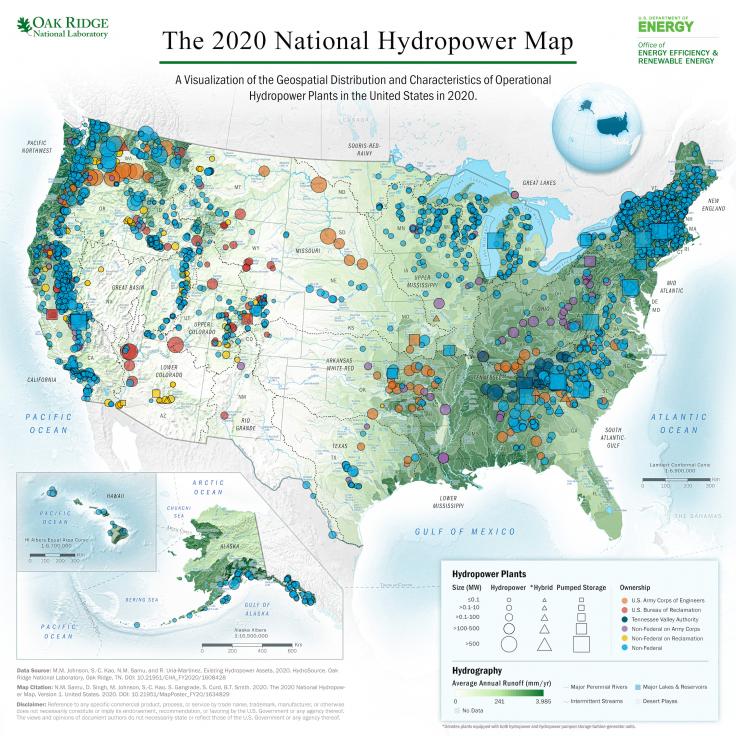
The 2020 National Hydropower Map. Credit: ORNL/U.S. Dept. of Energy
Overview/Objective
HydroSource is a comprehensive national water energy digital platform created by the U.S. Department of Energy’s Oak Ridge National Laboratory (ORNL). It serves as a key steward in maintaining and disseminating authoritative hydropower data to key stakeholders across the United States. The resource consists of hydropower-related data sets, data models, visualizations, and analytics tools that support and enable hydropower research and development on topics of national interest. These topics include U.S. hydropower market acceleration, deployment, resources characterization, environmental impact reduction, technology-to-market activities, and environmental impact assessment.
To aid in informing policy decisions, HydroSource is used by hydropower operators and developers; government agencies; decision makers across federal, state and local jurisdictions; nongovernmental organizations; academia; policy leaders; and the public. The digital platform increases transparency in hydropower projects and information, supports science-based analysis, enables robust research, fosters new project development, provides novel tools for data-driven environmental assessment, and informs strategic environmental permitting and mitigation.
Understanding the country’s existing hydropower fleet and potential hydropower resources is critical in supporting the broader U.S. hydropower industry. The U.S. hydropower fleet includes a mixture of federally and privately owned and operated facilities, some of which are under the jurisdiction of the Federal Energy Regulatory Commission. With the sponsorship of the DOE’s Hydropower and Hydrokinetic Office (H2O), ORNL initiated the National Hydropower Asset Assessment Program in 2010 to integrate and improve upon the capabilities of various energy–water geospatial data, and thus advance hydropower research and address the most pressing U.S. hydropower-related issues. The program was expanded into HydroSource in 2017.
The HydroSource platform is an ongoing effort by the H2O and ORNL, and has the end goal of improving the quality, functionality, dissemination, and sharing of detailed and scientific hydropower data.
Results
HydroSource was developed using the Findable, Accessible, Interoperable, and Reusable (FAIR) principles (Wilkinson et al. 2016). It enables data producers to publicly disseminate versions of their data and metadata in standardized formats with digital object identifiers and allows data users to search for and access the archived data and metadata.
The digital platform hosts multi-disciplinary science-based data with well-described attributes and metadata that meet domain-relevant community standards and aid in data discovery and reuse. It also provides centralized access to integrated and derived products to provide a singular source for flexible and user-friendly data that can be applied to address scenario-specific objectives.
Data include the following:
Existing Hydropower Assets (EHA) database—consists of comprehensive details on the locations and key characteristics of currently operational U.S. hydropower plants
U.S. Non-Powered Dam Characteristics Inventory—contains identifiers, locations, and a wide variety of characteristics that describe U.S. non-powered dams and their surroundings, including attributes related to the physical nature or design of a dam, environmental conditions, safety conditions, socioeconomic aspects, and hydropower development potential
New stream-reach development data set—identifies untapped U.S. stream-reaches with high (greater than 1 MW) and low (less than 1 MW) energy potential with more than 100 reaches with at least 100 MW of potential capacity
Hydropower licensing timeline and cost database—consists of timeline dates, lengths, project characteristics, license characteristics, and costs of hydropower licensing and relicensing for 107 randomly selected hydropower projects.
The Existing Hydropower Assets database, resource assessments, and data from external sources can be used to analyze the past, present, and projected future of the hydropower industry and pumped storage development trends for the nation as reported in the U.S. Hydropower Market Report.
Since its inception, HydroSource has served as a comprehensive data repository. HydroSource data have been used to inform policy decisions, identify future development opportunities, enable robust hydropower research, develop new tools for data-driven environmental assessment, and support strategic environmental permitting and mitigation. The content of HydroSource will continue to grow to support the development of national hydropower, which is a critical contributor to a reliable, affordable, and secure future energy portfolio.
Visit the Site
For more information, data, data use, maps, citation policy and resources visit hydrosource.ornl.gov.